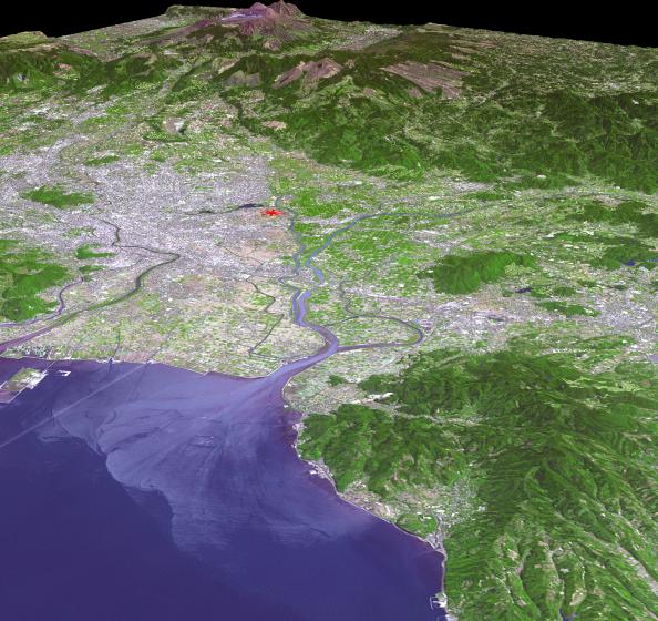
The magnitude 6.2 and 7.0 twin earthquakes that struck Japan's southern Kyushu Island on April 14 and 16, 2016, caused major damage and numerous casualties. The hypocenter was very shallow,6.2 miles or 10 kilometers, along the right-lateral strike slip Futagawa Fault, which goes directly through the city of Kumamoto. The shallow depth contributed to the severity of the shaking and damage. Japan is one of the most seismically active places on Earth. This perspective view, looking toward the Aso volcanic caldera, indicates the epicenter with a red star. The image was acquired April 20, 2016, and is located at 32.8 degrees north latitude, 130.7 degrees east longitude.
With its 14 spectral bands from the visible to the thermal infrared wavelength region and its high spatial resolution of 15 to 90 meters (about 50 to 300 feet), ASTER images Earth to map and monitor the changing surface of our planet. ASTER is one of five Earth-observing instruments launched Dec. 18, 1999, on Terra. The instrument was built by Japan's Ministry of Economy, Trade and Industry. A joint U.S./Japan science team is responsible for validation and calibration of the instrument and data products.
The broad spectral coverage and high spectral resolution of ASTER provides scientists in numerous disciplines with critical information for surface mapping and monitoring of dynamic conditions and temporal change. Example applications are: monitoring glacial advances and retreats; monitoring potentially active volcanoes; identifying crop stress; determining cloud morphology and physical properties; wetlands evaluation; thermal pollution monitoring; coral reef degradation; surface temperature mapping of soils and geology; and measuring surface heat balance.
The U.S. science team is located at NASA's Jet Propulsion Laboratory, Pasadena, Calif. The Terra mission is part of NASA's Science Mission Directorate, Washington, D.C.
More information about ASTER is available at http://asterweb.jpl.nasa.gov/.
 Planetary Data System


