PDS logoPlanetary Data System
PDS Information
Find a Node - Use these links to navigate to any of the 8 publicly accessible PDS Nodes.

This bar indicates that you are within the PDS enterprise which includes 6 science discipline nodes and 2 support nodes which are overseen by the Project Management Office at NASA's Goddard Space Flight Center (GSFC). Each node is led by an expert in the subject discipline, supported by an advisory group of other practitioners of that discipline, and subject to selection and approval under a regular NASA Research Announcement.
Click here to return to the Photojournal Home Page Click here to view a list of Photojournal Image Galleries Photojournal_inner_header
Latest Images  |  Spacecraft & Technology  |  Animations  |  Space Images App  |  Feedback  |  Photojournal Search  

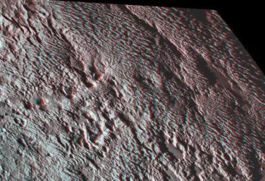
PIA20544: Pluto's Bladed Terrain in 3-D
 Target Name:  Pluto
 Is a satellite of:  Sol (our sun)
 Mission:  New Horizons
 Spacecraft:  New Horizons
 Instrument:  LORRI
MVIC
 Product Size:  855 x 582 pixels (w x h)
 Produced By:  Johns Hopkins University/APL
 Other  
Information: 
You will need 3D glasses
 Full-Res TIFF:  PIA20544.tif (1.494 MB)
 Full-Res JPEG:  PIA20544.jpg (179.9 kB)

Click on the image above to download a moderately sized image in JPEG format (possibly reduced in size from original)

Original Caption Released with Image:

One of the strangest landforms spotted by NASA's New Horizons spacecraft when it flew past Pluto last July was the "bladed" terrain just east of Tombaugh Regio, the informal name given to Pluto's large heart-shaped surface feature.

The blades are the dominant feature of a broad area informally named Tartarus Dorsa. They align from north to south, reach hundreds of feet high and are typically spaced a few miles apart. This remarkable landform, unlike any other seen in our solar system, is perched on a much broader set of rounded ridges that are separated by flat valley floors.

This amazing stereo view combines two images from the Ralph/Multispectral Visible Imaging Camera (MVIC) taken about 14 minutes apart on July 14, 2015. The first was taken when New Horizons was 16,000 miles (25,000 kilometers) away from Pluto, the second when the spacecraft was 10,000 miles (about 17,000 kilometers) away. Best resolution is approximately 1,000 feet (310 meters).

The Johns Hopkins University Applied Physics Laboratory in Laurel, Maryland, designed, built, and operates the New Horizons spacecraft, and manages the mission for NASA's Science Mission Directorate. The Southwest Research Institute, based in San Antonio, leads the science team, payload operations and encounter science planning. New Horizons is part of the New Frontiers Program managed by NASA's Marshall Space Flight Center in Huntsville, Alabama.

Image Credit:
NASA/Johns Hopkins University Applied Physics Laboratory/Southwest Research Institute

Image Addition Date:
2016-03-31