PDS logoPlanetary Data System
PDS Information
Find a Node - Use these links to navigate to any of the 8 publicly accessible PDS Nodes.

This bar indicates that you are within the PDS enterprise which includes 6 science discipline nodes and 2 support nodes which are overseen by the Project Management Office at NASA's Goddard Space Flight Center (GSFC). Each node is led by an expert in the subject discipline, supported by an advisory group of other practitioners of that discipline, and subject to selection and approval under a regular NASA Research Announcement.
Click here to return to the Photojournal Home Page Click here to view a list of Photojournal Image Galleries Photojournal_inner_header
Latest Images  |  Spacecraft & Technology  |  Animations  |  Space Images App  |  Feedback  |  Photojournal Search  

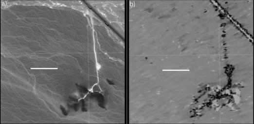
PIA20377: Disturbance at Peru's Nasca World Heritage Site seen by NASA's UAVSAR
 Target Name:  Earth
 Is a satellite of:  Sol (our sun)
 Mission:  UAVSAR
 Instrument:  L-Band UAVSAR
 Product Size:  1800 x 882 pixels (w x h)
 Produced By:  JPL
 Full-Res TIFF:  PIA20377.tif (1.158 MB)
 Full-Res JPEG:  PIA20377.jpg (112.2 kB)

Click on the image above to download a moderately sized image in JPEG format (possibly reduced in size from original)

Original Caption Released with Image:

a) Google Earth image © 2015 Digital Globe image showing the Pan-American Highway in upper right, and an unpaved road from the highway to a hilly area used by tourists to view the Peruvian Nasca World Heritage Site geoglyphs. b) Calibrated correlation image from NASA's Uninhabited Aerial Vehicle Synthetic Aperture Radar (UAVSAR) overlaid in Google Earth. Black corresponds to decorrelation, typically due to disturbance between the two observations (in March 2013 and March 2015), while grey and light grey correspond to areas with minimal decorrelation. The white line corresponds to 100 meters, North is up. Coordinates are 14.707S, 75.103W.

NASA's Uninhabited Aerial Vehicle Synthetic Aperture Radar (UAVSAR), developed and managed by the Jet Propulsion Laboratory, Pasadena, California, can record changes on the ground beneath the aircraft that occur between multiple flights, which take exactly the same flight path. The instrument is used to monitor how volcanoes, earthquakes, and other natural hazards are changing Earth. Principal investigator Bruce Chapman of JPL noted that UAVSAR is ideally suited for observing the Nasca site because the region has virtually no vegetation and receives no rainfall whatsoever in most years, meaning that natural disturbances are minimal.

Image Credit:
NASA/JPL-Caltech/2015 Google, Digital Globe

Image Addition Date:
2016-02-05