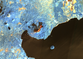
Close-up View
Click on the image for larger versionMomotombo volcano, Nicaragua, began erupting on Dec. 1, 2015, after more than a century of inactivity. On Dec. 4, 2015, the Advanced Land Imager (ALI) on NASA's Earth Observing 1 (EO-1) spacecraft observed the new eruption. This image is created from infrared data, and shows the incandescent active vent at the summit of the volcano and lava flowing down the side of the volcano. These data are being examined by scientists to determine where lava will flow, allowing assessment of possible threats to local infrastructure. The EO-1 data were obtained at an altitude of 438 miles (705 kilometers) and at a resolution of 98 feet (30 meters) per pixel at different visible and infrared wavelengths. The ALI image is 23 miles (37 kilometers) wide.
The EO-1 spacecraft is managed by NASA's Goddard Space Flight Center, Greenbelt, Maryland. EO-1 is the satellite remote-sensing asset used by the Volcano Sensor Web developed by NASA's Jet Propulsion Laboratory, Pasadena, California, which is being used to monitor this, and other, volcanic eruptions around the world.
