PDS logoPlanetary Data System
PDS Information
Find a Node - Use these links to navigate to any of the 8 publicly accessible PDS Nodes.

This bar indicates that you are within the PDS enterprise which includes 6 science discipline nodes and 2 support nodes which are overseen by the Project Management Office at NASA's Goddard Space Flight Center (GSFC). Each node is led by an expert in the subject discipline, supported by an advisory group of other practitioners of that discipline, and subject to selection and approval under a regular NASA Research Announcement.
Click here to return to the Photojournal Home Page Click here to view a list of Photojournal Image Galleries Photojournal_inner_header
Latest Images  |  Spacecraft & Technology  |  Animations  |  Space Images App  |  Feedback  |  Photojournal Search  

PIA20159: A Landing Site for ExoMars 2016
 Target Name:  Mars
 Is a satellite of:  Sol (our sun)
 Mission:  Mars Reconnaissance Orbiter (MRO)
 Spacecraft:  Mars Reconnaissance Orbiter (MRO)
 Instrument:  HiRISE
 Product Size:  2880 x 1800 pixels (w x h)
 Produced By:  Johns Hopkins University/APL
 Other  
Information: 
Other products from ESP_042806_1785
 Full-Res TIFF:  PIA20159.tif (15.56 MB)
 Full-Res JPEG:  PIA20159.jpg (1.932 MB)

Click on the image above to download a moderately sized image in JPEG format (possibly reduced in size from original)

Original Caption Released with Image:

Click here for larger version of PIA20159
Map Projected Browse Image
Click on the image for larger version

In March 2016, the European Space Agency in partnership with Roscosmos will launch the ExoMars Trace Gas Orbiter. This orbiter will also carry an Entry, Descent, and Landing Demonstration Module (EDM): a lander designed primarily to demonstrate the capability to land on Mars. The EDM will survive for only a few days, running on battery power, but will make a few environmental measurements.

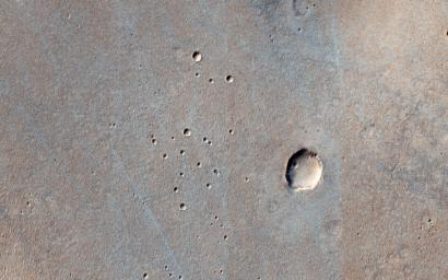
The landing site is the flattest, safest place on Mars: part of Meridiani Planum, close to where the Opportunity rover landed. This image shows what this terrain is like: very flat and featureless. A full-resolution sample reveals the major surface features: small craters and wind ripples. HiRISE has been imaging the landing site region in advance of the landing, and will re-image the site after landing to identify the major pieces of hardware: heat shield, backshell with parachute, and the lander itself. The distribution of these pieces will provide information about the entry, descent and landing.

Click here for more information about ESA's ExoMars Programme.

This is a stereo pair with ESP_034986_1785.

The University of Arizona, Tucson, operates HiRISE, which was built by Ball Aerospace & Technologies Corp., Boulder, Colo. NASA's Jet Propulsion Laboratory, a division of the California Institute of Technology in Pasadena, manages the Mars Reconnaissance Orbiter Project for NASA's Science Mission Directorate, Washington.

Image Credit:
NASA/JPL-Caltech/Univ. of Arizona

Image Addition Date:
2015-11-27