PDS logoPlanetary Data System
PDS Information
Find a Node - Use these links to navigate to any of the 8 publicly accessible PDS Nodes.

This bar indicates that you are within the PDS enterprise which includes 6 science discipline nodes and 2 support nodes which are overseen by the Project Management Office at NASA's Goddard Space Flight Center (GSFC). Each node is led by an expert in the subject discipline, supported by an advisory group of other practitioners of that discipline, and subject to selection and approval under a regular NASA Research Announcement.
Click here to return to the Photojournal Home Page Click here to view a list of Photojournal Image Galleries Photojournal_inner_header
Latest Images  |  Spacecraft & Technology  |  Animations  |  Space Images App  |  Feedback  |  Photojournal Search  

PIA20000: Dawn HAMO Image 57
 Target Name:  Ceres
 Is a satellite of:  Sol (our sun)
 Mission:  Dawn
 Spacecraft:  Dawn
 Instrument:  Framing Camera
 Product Size:  1024 x 1024 pixels (w x h)
 Produced By:  JPL
 Full-Res TIFF:  PIA20000.tif (1.05 MB)
 Full-Res JPEG:  PIA20000.jpg (148.8 kB)

Click on the image above to download a moderately sized image in JPEG format (possibly reduced in size from original)

Original Caption Released with Image:

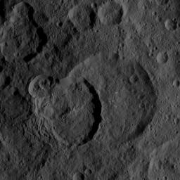
This image of Ceres, taken by NASA's Dawn spacecraft, demonstrates how the relative ages of impact craters can be revealed by their positions relative to each other. In many cases, as with the craters at the center of this view, younger craters are seen to be "superposed" on -- meaning located on top of -- older craters below.

The largest feature in the image scene is the 48-mile-wide (77-kilometer-wide) Geshtin crater, which is superposed by the younger Datan crater, which is 37 miles (60 kilometers) in diameter. On its upper-left rim, Datan is superposed by a smaller, even younger unnamed crater.

The image was taken on Oct. 2, 2015, from an altitude of 915 miles (1,470 kilometers), and has a resolution of 450 feet (140 meters) per pixel. The image is centered at approximately 59 degrees north latitude, 258 degrees east longitude.

Dawn's mission is managed by JPL for NASA's Science Mission Directorate in Washington. Dawn is a project of the directorate's Discovery Program, managed by NASA's Marshall Space Flight Center in Huntsville, Alabama. UCLA is responsible for overall Dawn mission science. Orbital ATK, Inc., in Dulles, Virginia, designed and built the spacecraft. The German Aerospace Center, the Max Planck Institute for Solar System Research, the Italian Space Agency and the Italian National Astrophysical Institute are international partners on the mission team. For a complete list of acknowledgments, see http://dawn.jpl.nasa.gov/mission.

For more information about the Dawn mission, visit http://dawn.jpl.nasa.gov.

Image Credit:
NASA/JPL-Caltech/UCLA/MPS/DLR/IDA

Image Addition Date:
2015-11-11