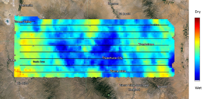
Day 1 (8/2/2015)
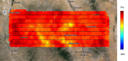
Day 2 (8/5/2015)
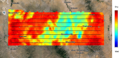
Day 3 (8/8/2015)
Click on an image above for larger viewNASA's SMAP (Soil Moisture Active Passive) satellite observatory conducted a field experiment as part of its soil moisture data product validation program in southern Arizona on Aug. 2-18, 2015. The images here represent the distribution of soil moisture over the SMAPVEX15 (SMAP Validation Experiment 2015) experiment domain, as measured by the Passive Active L-band System (PALS) developed by NASA's Jet Propulsion Laboratory, Pasadena, California, which was installed onboard a DC-3 aircraft operated by Airborne Imaging, Inc. Blue and green colors denote wet conditions and dry conditions are marked by red and orange. The black lines show the nominal flight path of PALS.
The measurements show that on the first day, the domain surface was wet overall, but had mostly dried down by the second measurement day. On the third day, there was a mix of soil wetness. The heterogeneous soil moisture distribution over the domain is typical for the area during the North American Monsoon season and provides excellent conditions for SMAP soil moisture product validation and algorithm enhancement.
The images are based on brightness temperature measured by the PALS instrument gridded on a grid with 0.6-mile (1-kilometer) pixel size. They do not yet compensate for surface characteristics, such as vegetation and topography. That work is currently in progress.
SMAP is managed for NASA's Science Mission Directorate in Washington by JPL. JPL is responsible for project management, system engineering, instrument management, the radar instrument, mission operations and the ground data system. NASA's Launch Services Program at NASA's Kennedy Space Center in Florida is responsible for launch management. JPL is managed for NASA by the California Institute of Technology in Pasadena.
For more information about SMAP, visit http://smap.jpl.nasa.gov.


