PDS logoPlanetary Data System
PDS Information
Find a Node - Use these links to navigate to any of the 8 publicly accessible PDS Nodes.

This bar indicates that you are within the PDS enterprise which includes 6 science discipline nodes and 2 support nodes which are overseen by the Project Management Office at NASA's Goddard Space Flight Center (GSFC). Each node is led by an expert in the subject discipline, supported by an advisory group of other practitioners of that discipline, and subject to selection and approval under a regular NASA Research Announcement.
Click here to return to the Photojournal Home Page Click here to view a list of Photojournal Image Galleries Photojournal_inner_header
Latest Images  |  Spacecraft & Technology  |  Animations  |  Space Images App  |  Feedback  |  Photojournal Search  

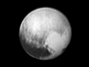
PIA19705: New Details on Pluto
 Target Name:  Pluto
 Is a satellite of:  Sol (our sun)
 Mission:  New Horizons
 Spacecraft:  New Horizons
 Instrument:  LORRI
 Product Size:  2998 x 2248 pixels (w x h)
 Produced By:  Johns Hopkins University/APL
 Full-Res TIFF:  PIA19705.tif (6.749 MB)
 Full-Res JPEG:  PIA19705.jpg (157.9 kB)

Click on the image above to download a moderately sized image in JPEG format (possibly reduced in size from original)

Original Caption Released with Image:

Click here for larger annotated version of PIA19705
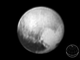
Annotated Version
Click on the image for larger annotated version

This image of Pluto was taken by New Horizons' Long Range Reconnaissance Imager (LORRI) at 4:18 UT on July 9, 2015, from a range of 3.9 million miles (6.3 million kilometers). It reveals new details on the surface of Pluto, including complex patterns in the transition between the very dark equatorial band (nicknamed "the whale"), which occupies the lower part of the image, and the brighter northern terrain. The bright arc at the bottom of the disk shows that there is more bright terrain beyond the southern margin of the "whale." The side of Pluto that will be studied in great detail during the close encounter on July 14 is now rotating off the visible disk on the right hand side, and will not be seen again until shortly before closest approach.

Three consecutive images were combined and sharpened, using a process called deconvolution, to create this view. Deconvolution enhances real detail but can also generate spurious features, including the bright edge seen on the upper and left margins of the disk (though the bright margin on the bottom of the disk is real).

The wireframe globe shows the orientation of Pluto in the image: thicker lines indicate the equator and the prime meridian (the direction facing Charon). Central longitude on Pluto is 86°.

The Johns Hopkins University Applied Physics Laboratory in Laurel, Maryland, designed, built, and operates the New Horizons spacecraft, and manages the mission for NASA's Science Mission Directorate. The Southwest Research Institute, based in San Antonio, leads the science team, payload operations and encounter science planning. New Horizons is part of the New Frontiers Program managed by NASA's Marshall Space Flight Center in Huntsville, Alabama.

For more information about the New Horizons mission, visit http://www.nasa.gov/newhorizons and http://pluto.jhuapl.edu.

Image Credit:
NASA/Johns Hopkins University Applied Physics Laboratory/Southwest Research Institute

Image Addition Date:
2015-07-10