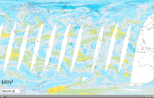
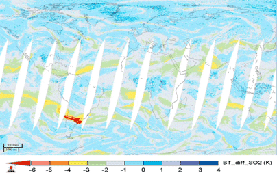
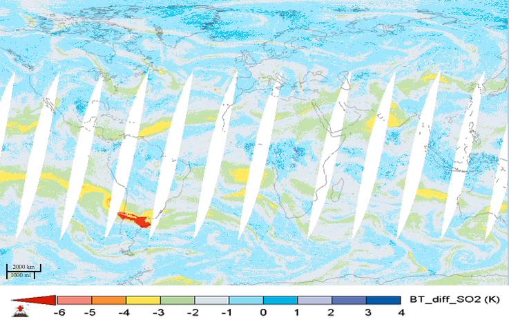
Click on the image for the animationFor the first time in 40 years, the Calbuco volcano in southern Chile erupted on April 22, 2015. The eruption caused airline flight cancellations in Chile, Argentina and Uruguay and the evacuation of approximately 4,000 people. This movie shows alternating day and nighttime views of the plume of sulfur dioxide gas emitted by Calbuco, as observed by NASA's Atmospheric Infrared Sounder (AIRS) instrument on NASA's Aqua spacecraft, from April 22 to May 5, 2015. Significant amounts of sulfur dioxide are shown in bright red. The largest plume is apparent over South America during the initial eruption on April 22. The plume is then carried by winds across the south Atlantic Ocean and southern Africa. A second large eruption on April 29 produced a smaller plume.
Volcanic sulfur dioxide can be an important factor in climate. Some of it is carried into Earth's stratosphere, where it is transformed into highly reflective droplets of sulfuric acid. By reflecting sunlight, these droplets can cool Earth. Large eruptions, like Mt. Pinatubo in 1991, cool our planet and disrupt rainfall patterns. Though an impressive eruption, Calbuco is expected to have only a small impact on Earth's climate.
AIRS sulfur dioxide data are used to alert the air transportation industry about volcanic eruptions. Combined with measurements of volcanic ash, they provide a long-term record of the effects of volcanoes on the atmosphere. AIRS Near-Real Time (NRT) processing and imagery are provided by a collaborative effort between NASA's Goddard Earth Science Data and Information Services Center (GES DISC), and the AIRS Team at NASA's Jet Propulsion Laboratory, Pasadena, California. AIRS NRT is an element of the Land, Atmosphere Near real-time Capability for NASA's Earth Observing System (LANCE). More information on LANCE is available at http://earthdata.nasa.gov/lance.
About AIRS
The Atmospheric Infrared Sounder, AIRS, in conjunction with the Advanced Microwave Sounding Unit, AMSU, senses emitted infrared and microwave radiation from Earth to provide a three-dimensional look at Earth's weather and climate. Working in tandem, the two instruments make simultaneous observations all the way down to Earth's surface, even in the presence of heavy clouds. With more than 2,000 channels sensing different regions of the atmosphere, the system creates a global, three-dimensional map of atmospheric temperature and humidity, cloud amounts and heights, greenhouse gas concentrations, and many other atmospheric phenomena. Launched into Earth orbit in 2002, the AIRS and AMSU instruments fly onboard NASA's Aqua spacecraft and are managed by NASA's Jet Propulsion Laboratory in Pasadena, Calif., under contract to NASA. JPL is a division of the California Institute of Technology in Pasadena.
More information about AIRS can be found at http://airs.jpl.nasa.gov.