PDS logoPlanetary Data System
PDS Information
Find a Node - Use these links to navigate to any of the 8 publicly accessible PDS Nodes.

This bar indicates that you are within the PDS enterprise which includes 6 science discipline nodes and 2 support nodes which are overseen by the Project Management Office at NASA's Goddard Space Flight Center (GSFC). Each node is led by an expert in the subject discipline, supported by an advisory group of other practitioners of that discipline, and subject to selection and approval under a regular NASA Research Announcement.
Click here to return to the Photojournal Home Page Click here to view a list of Photojournal Image Galleries Photojournal_inner_header
Latest Images  |  Spacecraft & Technology  |  Animations  |  Space Images App  |  Feedback  |  Photojournal Search  

PIA19231: Melting Point
 Target Name:  Mercury
 Is a satellite of:  Sol (our sun)
 Mission:  MESSENGER
 Spacecraft:  MESSENGER
 Instrument:  MDIS - Narrow Angle
 Product Size:  512 x 512 pixels (w x h)
 Produced By:  Johns Hopkins University/APL
 Full-Res TIFF:  PIA19231.tif (262.6 kB)
 Full-Res JPEG:  PIA19231.jpg (25.79 kB)

Click on the image above to download a moderately sized image in JPEG format (possibly reduced in size from original)

Original Caption Released with Image:

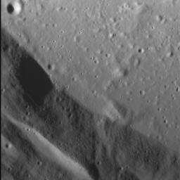
Impact crater floors are commonly flat and relatively smooth, the result of the cooling and solidification of impact melt generated by the impact event itself. Often, the pool of impact melt cracks as it cools, a process well illustrated by the striking Abedin crater. Although not visible in the frame above, this crater also hosts cooling cracks on its floor. It also boasts numerous terraces along its inner wall, which likely formed after the impact melt solidified. Note how the fine-grained texture of the inner walls contrasts with the crater's floor.

This image was acquired as a high-resolution targeted observation. Targeted observations are images of a small area on Mercury's surface at resolutions much higher than the 200-meter/pixel morphology base map. It is not possible to cover all of Mercury's surface at this high resolution, but typically several areas of high scientific interest are imaged in this mode each week.

Date acquired: January 25, 2015
Image Mission Elapsed Time (MET): 64531185
Image ID: 7861875
Instrument: Narrow Angle Camera (NAC) of the Mercury Dual Imaging System (MDIS)
Center Latitude: 27.1°
Center Longitude: 69.1° E
Resolution: 14.8 meters/pixel
Scale: The left-to-right field of view in this image is about 8 km (5 mi.) across
Incidence Angle: 70.8°
Emission Angle: 5.1°
Phase Angle: 65.7°
North is up in this image.

The MESSENGER spacecraft is the first ever to orbit the planet Mercury, and the spacecraft's seven scientific instruments and radio science investigation are unraveling the history and evolution of the Solar System's innermost planet. During the first two years of orbital operations, MESSENGER acquired over 150,000 images and extensive other data sets. MESSENGER is capable of continuing orbital operations until early 2015.

For information regarding the use of images, see the MESSENGER image use policy.

Image Credit:
NASA/Johns Hopkins University Applied Physics Laboratory/Carnegie Institution of Washington

Image Addition Date:
2015-03-06