PDS logoPlanetary Data System
PDS Information
Find a Node - Use these links to navigate to any of the 8 publicly accessible PDS Nodes.

This bar indicates that you are within the PDS enterprise which includes 6 science discipline nodes and 2 support nodes which are overseen by the Project Management Office at NASA's Goddard Space Flight Center (GSFC). Each node is led by an expert in the subject discipline, supported by an advisory group of other practitioners of that discipline, and subject to selection and approval under a regular NASA Research Announcement.
Click here to return to the Photojournal Home Page Click here to view a list of Photojournal Image Galleries Photojournal_inner_header
Latest Images  |  Spacecraft & Technology  |  Animations  |  Space Images App  |  Feedback  |  Photojournal Search  

PIA19150: Adaptive Caching Concept
 Target Name:  Mars
 Is a satellite of:  Sol (our sun)
 Mission:  Mars 2020 Rover
 Product Size:  960 x 485 pixels (w x h)
 Produced By:  JPL
 Full-Res TIFF:  PIA19150.tif (1.398 MB)
 Full-Res JPEG:  PIA19150.jpg (65.26 kB)

Click on the image above to download a moderately sized image in JPEG format (possibly reduced in size from original)

Original Caption Released with Image:

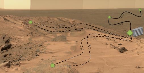
This diagram, superimposed on a photo of Martian landscape, illustrates a concept called "adaptive caching," which is in development for NASA's 2020 Mars rover mission.

In addition to the investigations that the Mars 2020 rover will conduct on Mars, the rover will collect carefully selected samples of Mars rock and soil and cache them to be available for possible return to Earth if a Mars sample-return mission is scheduled and flown.

Each sample will be stored in a sealed tube. Adaptive caching would result in a set of samples, up to the maximum number of tubes carried on the rover, being placed on the surface at the discretion of the mission operators. The tubes holding the collected samples would not go into a surrounding container.

In this illustration, green dots indicate "regions of interest," where samples might be collected. The green diamond indicates one region of interest serving as the depot for the cache. The green X at upper right represents the landing site. The solid black line indicates the rover's route during its prime mission, and the dashed black line indicates its route during an extension of the mission.

The base image is a portion of the "Everest Panorama" taken by the panoramic camera on NASA's Mars Exploration Rover Spirit at the top of Husband Hill in 2005 (see PIA03095).

NASA's Jet Propulsion Laboratory, a division of the California Institute of Technology, Pasadena, manages NASA's Mars Exploration Program for the NASA Science Mission Directorate, Washington.

Image Credit:
NASA/JPL-Caltech/Cornell Univ./Arizona State Univ.

Image Addition Date:
2015-06-10