PDS logoPlanetary Data System
PDS Information
Find a Node - Use these links to navigate to any of the 8 publicly accessible PDS Nodes.

This bar indicates that you are within the PDS enterprise which includes 6 science discipline nodes and 2 support nodes which are overseen by the Project Management Office at NASA's Goddard Space Flight Center (GSFC). Each node is led by an expert in the subject discipline, supported by an advisory group of other practitioners of that discipline, and subject to selection and approval under a regular NASA Research Announcement.
Click here to return to the Photojournal Home Page Click here to view a list of Photojournal Image Galleries Photojournal_inner_header
Latest Images  |  Spacecraft & Technology  |  Animations  |  Space Images App  |  Feedback  |  Photojournal Search  

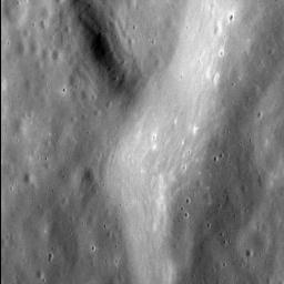
PIA19026: The Rolling Hills of Mercury
 Target Name:  Mercury
 Is a satellite of:  Sol (our sun)
 Mission:  MESSENGER
 Spacecraft:  MESSENGER
 Instrument:  MDIS - Narrow Angle
 Product Size:  1024 x 1024 pixels (w x h)
 Produced By:  Johns Hopkins University/APL
 Full-Res TIFF:  PIA19026.tif (1.05 MB)
 Full-Res JPEG:  PIA19026.jpg (225.3 kB)

Click on the image above to download a moderately sized image in JPEG format (possibly reduced in size from original)

Original Caption Released with Image:

This incredible image attests to how the MESSENGER spacecraft is now able to resolve Mercury's surface: with a resolution of a little more than five meters (seventeen feet) per pixel, a person of average walking pace could cross this scene in about an hour.

The image shows the fine texture on the inner wall of an unnamed impact basin 100 km (62 mi.) in diameter, situated immediately west of the larger Dali basin. Both this basin and its larger neighbor are filled with smooth plains and deformed by lobate scarps and wrinkle ridges.

This image was acquired as a high-resolution targeted observation. Targeted observations are images of a small area on Mercury's surface at resolutions much higher than the 200-meter/pixel morphology base map. It is not possible to cover all of Mercury's surface at this high resolution, but typically several areas of high scientific interest are imaged in this mode each week.

Date acquired: November 21, 2014
Image Mission Elapsed Time (MET): 58910898
Image ID: 7472673
Instrument: Narrow Angle Camera (NAC) of the Mercury Dual Imaging System (MDIS)
Center Latitude: 45.5°
Center Longitude: 115.6° E
Resolution: 5.3 meters/pixel
Scale: The left-to-right field of view in this image is about 5.5 km (3.4 mi.) across
Incidence Angle: 52.5°
Emission Angle: 46.6°
Phase Angle: 99.1°
North is to the lower right of this image.

The MESSENGER spacecraft is the first ever to orbit the planet Mercury, and the spacecraft's seven scientific instruments and radio science investigation are unraveling the history and evolution of the Solar System's innermost planet. MESSENGER acquired over 150,000 images and extensive other data sets. MESSENGER is capable of continuing orbital operations until early 2015.

For information regarding the use of images, see the MESSENGER image use policy.

Image Credit:
NASA/Johns Hopkins University Applied Physics Laboratory/Carnegie Institution of Washington

Image Addition Date:
2015-01-23