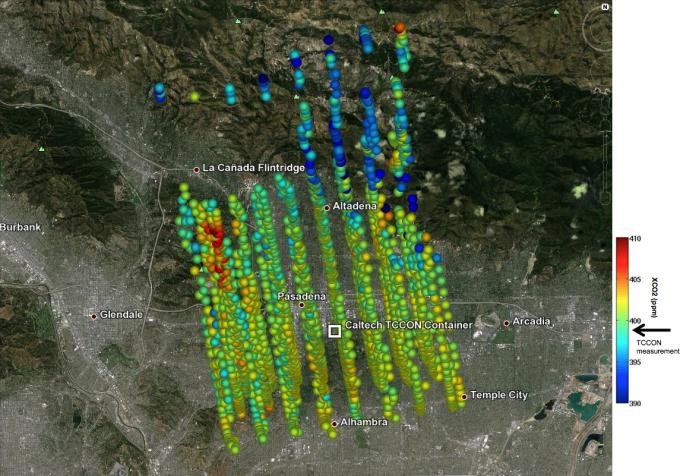
This image shows Orbiting Carbon Observatory-2 (OCO-2) measurements of carbon dioxide levels over Pasadena and the northern Los Angeles basin on Sept. 5, 2014. Each colored dot represents a single measurement of the greenhouse gas made during a five-minute overflight of the area by the carbon-counting spacecraft. The satellite recorded a level of 402 parts per million of carbon dioxide over the heart of Pasadena, that is, 402 molecules of carbon out of every million molecules of air. This is a good preliminary match for a simultaneous measurement made at a station in the Total Carbon Column Observing Network (TCCON) on the campus of the California Institute of Technology, Pasadena (box at center). The TCCON station recorded a carbon dioxide level of 399 parts per million.
The image is among the first made during the process of validating the spacecraft's observations against TCCON data in preparation for releasing them to the scientific community. "The close agreement between the ground-based TCCON and space-based OCO-2 estimates is extremely encouraging at this early stage of analysis," said Annmarie Eldering, the OCO-2 deputy project scientist. OCO-2 was launched on July 2.
Eldering said that the greatest variations in carbon dioxide concentration, such as what looks like a carbon dioxide hot spot on the left side of the observation swaths, are likely to be measurement errors resulting from the extremely steep terrain in the region. The observatory requires a very precise measurement of the distance between ground and spacecraft to produce the most accurate possible estimate of carbon dioxide. However, Eldering would not completely rule out the possibility that the anomalies were real and had a physical cause, such as auto emissions pooling in a canyon or local emissions. "Understanding the massive new measurement set of OCO-2 provides many interesting scientific puzzles like this, which our team of scientists truly enjoys."
OCO-2 is managed by JPL for NASA's Science Mission Directorate, Washington. Orbital Sciences Corporation, Dulles, Va., built the spacecraft and provides mission operations under JPL's leadership. The California Institute of Technology in Pasadena manages JPL for NASA.
For more information on OCO-2, visit: http://oco.jpl.nasa.gov/ and http://www.nasa.gov/oco2.
 Planetary Data System


