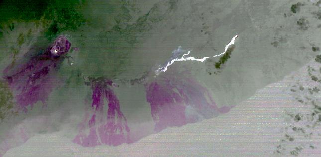
On June 27, 2014, a new vent opened on Hawaii's Puu Oo vent, on the eastern flank of Kilauea volcano. A slow-moving lava flow has been flowing inexorably northeastward through the dense forest and in the direction of homes in the Puna district. At its current flow rate, the U.S. Geological Survey estimates that the lava flow could cross Pahoa Village Road, the main road through Pahoa town, on or around September 25. The September 18 nighttime thermal infrared image from the Advanced Spaceborne Thermal Emission and Reflection Radiometer (ASTER) instrument on NASA's Terra spacecraft shows the hot lava flow in white, extending about 11 miles (17 kilometers) from the vent. The bright spot on the left side of the image is molten lava within Halemaumau crater. The magenta colored areas are recent lava flows from the last 50 years. The image covers an area of 17 by 36 miles (28 by 58 kilometers), and is located at 19.6 degrees north, 155.1 degrees west.
With its 14 spectral bands from the visible to the thermal infrared wavelength region and its high spatial resolution of 15 to 90 meters (about 50 to 300 feet), ASTER images Earth to map and monitor the changing surface of our planet. ASTER is one of five Earth-observing instruments launched Dec. 18, 1999, on Terra. The instrument was built by Japan's Ministry of Economy, Trade and Industry. A joint U.S./Japan science team is responsible for validation and calibration of the instrument and data products.
The broad spectral coverage and high spectral resolution of ASTER provides scientists in numerous disciplines with critical information for surface mapping and monitoring of dynamic conditions and temporal change. Example applications are: monitoring glacial advances and retreats; monitoring potentially active volcanoes; identifying crop stress; determining cloud morphology and physical properties; wetlands evaluation; thermal pollution monitoring; coral reef degradation; surface temperature mapping of soils and geology; and measuring surface heat balance.
The U.S. science team is located at NASA's Jet Propulsion Laboratory, Pasadena, Calif. The Terra mission is part of NASA's Science Mission Directorate, Washington, D.C.
More information about ASTER is available at http://asterweb.jpl.nasa.gov/.
 Planetary Data System


