 |  |
| Figure 1 | Figure 2 |
Click on an individual image for full resolution imageE-DECIDER (Emergency Data Enhanced Cyber-Infrastructure for Disaster Evaluation and Response), a NASA-funded disaster decision support system, provided a number of rapid response map data products to decision makers at the California Earthquake Clearinghouse using XchangeCore Web Service Data Orchestration following its activation for the Aug. 24, 2014 magnitude 6.0 earthquake in Napa, California.
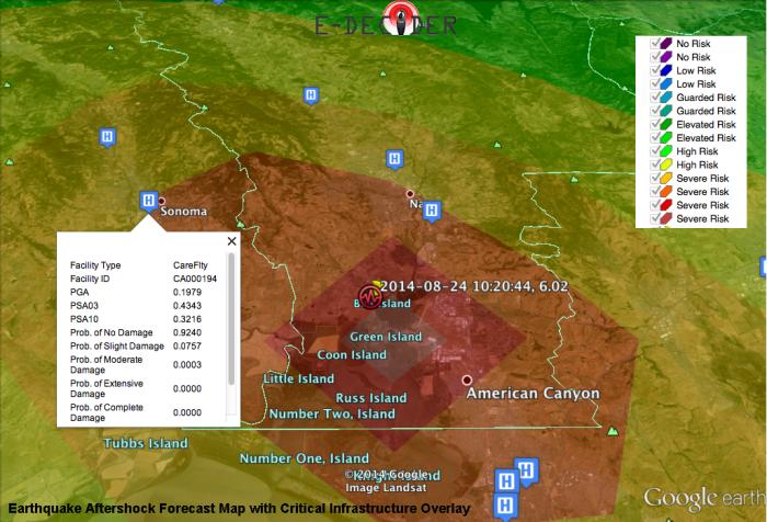
Earthquake Aftershock Forecast Map with Critical Infrastructure Overlay
The Aftershock Forecast Map (main image) highlights areas where aftershocks are likely to occur. These maps show estimated aftershock risk in a color scale -- warmer colors represent higher risk and cooler colors lower risk. Using the critical infrastructure overlays with damage estimates, decision makers can better direct response efforts. For example, the map shows an emergency care facility within the affected area that was predicted to sustain slight damage, which can later be verified in the field.
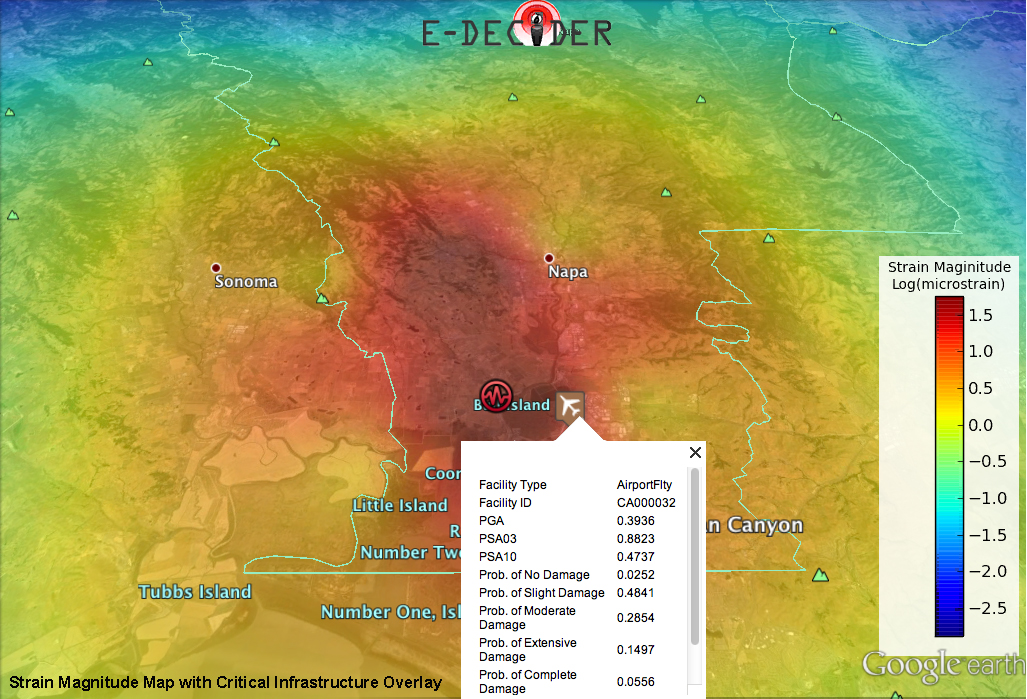
Strain Magnitude Map with Critical Infrastructure Overlay
The Strain Magnitude Map (Figure 1) highlights areas where greatest ground deformation (motion) has occurred based on a fault model. Once GPS observations are available, the model can be refined and deformation better constrained. These maps provide an early estimate of where the deformation has occurred, and where damage may be localized. Using the critical infrastructure overlays with damage estimates, decision makers can direct response efforts. The map shows an airport in the affected area that was predicted to have sustained minor damage. The infrastructure information contains both a damage estimate and location to help direct response efforts. With later satellite observations and field reconnaissance, this information can be verified.
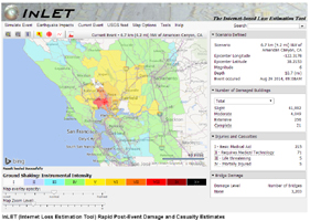
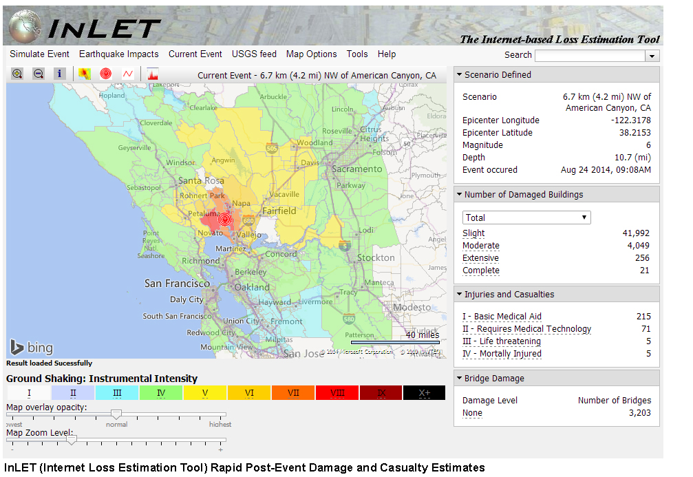
InLET (Internet Loss Estimation Tool) Post-Event Damage and Casualty Estimates
InLET (Internet-based Loss Estimation Tool) (Figure 2), provides immediate post-event estimates of casualties and building damage. These results were provided to E-DECIDER by their collaborators, ImageCat, Inc. and the Community Stakeholder Network (CSN).
InLET performs loss/impact simulations using USGS earthquake ground motion data and FEMA HAZUS damage estimation technology. The damage and loss values generated are only approximations of the impacts caused by an earthquake in the affected region. In the case of an actual earthquake event, the damage and losses could be different.
Results are appropriate for planning purposes and for early-post event response only, when more detailed data are not available. These results can be generated within a few minutes of the earthquake (as soon as a ShakeMap is available) and distributed to decision makers.
E-DECIDER is a collaboration between NASA's Jet Propulsion Laboratory, Pasadena, California; ImageCat, Inc., Long Beach, California; Indiana University; University of California, Davis; University of Missouri Kansas City; and the US Geological Survey. E-DECIDER works in partnership with the California Earthquake Clearinghouse and its partners, including the California Office of Emergency Services, the California Geological Survey, the Earthquake Engineering Research Institute, FEMA and others. E-DECIDER is sponsored by the Disasters Focus Area of the Applied Sciences Program at NASA.
For more information, see http://e-decider.org/content/napa-earthquake-august-2014.
 Planetary Data System


