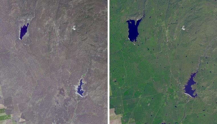
The effects of California's severe multiyear drought can be clearly seen in this pair of images acquired by the Advanced Spaceborne Thermal Emission and Reflection Radiometer (ASTER) instrument on NASA's Terra spacecraft. The images show an area northeast of Madera, in the Sierra Nevada Moutains foothills between Yosemite National Park and the San Joaquin Valley. The right image was acquired April 5, 2011, when winter rainfall was at a normal level. H.V. Eastman and Hensley Lakes, and numerous stock tanks, are full, and green vegetation carpets the landscape. Three years later, when the left image was acquired on May 15, 2014, the drying up of the reservoirs is apparent, as is the browning of the grass- and shrub-lands. The images cover an area of 12.1 by 14 miles (19.5 by 22.5 kilometers), and are located at 37.2 degrees north, 119.9 degrees west.
With its 14 spectral bands from the visible to the thermal infrared wavelength region and its high spatial resolution of 15 to 90 meters (about 50 to 300 feet), ASTER images Earth to map and monitor the changing surface of our planet. ASTER is one of five Earth-observing instruments launched Dec. 18, 1999, on Terra. The instrument was built by Japan's Ministry of Economy, Trade and Industry. A joint U.S./Japan science team is responsible for validation and calibration of the instrument and data products.
The broad spectral coverage and high spectral resolution of ASTER provides scientists in numerous disciplines with critical information for surface mapping and monitoring of dynamic conditions and temporal change. Example applications are: monitoring glacial advances and retreats; monitoring potentially active volcanoes; identifying crop stress; determining cloud morphology and physical properties; wetlands evaluation; thermal pollution monitoring; coral reef degradation; surface temperature mapping of soils and geology; and measuring surface heat balance.
The U.S. science team is located at NASA's Jet Propulsion Laboratory, Pasadena, Calif. The Terra mission is part of NASA's Science Mission Directorate, Washington, D.C.
More information about ASTER is available at http://asterweb.jpl.nasa.gov/.