PDS logoPlanetary Data System
PDS Information
Find a Node - Use these links to navigate to any of the 8 publicly accessible PDS Nodes.

This bar indicates that you are within the PDS enterprise which includes 6 science discipline nodes and 2 support nodes which are overseen by the Project Management Office at NASA's Goddard Space Flight Center (GSFC). Each node is led by an expert in the subject discipline, supported by an advisory group of other practitioners of that discipline, and subject to selection and approval under a regular NASA Research Announcement.
Click here to return to the Photojournal Home Page Click here to view a list of Photojournal Image Galleries Photojournal_inner_header
Latest Images  |  Spacecraft & Technology  |  Animations  |  Space Images App  |  Feedback  |  Photojournal Search  

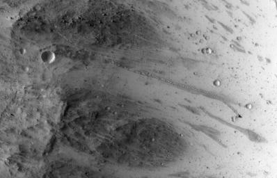
PIA18594: An Irregular, Upright Boulder on Mars
 Target Name:  Mars
 Is a satellite of:  Sol (our sun)
 Mission:  Mars Reconnaissance Orbiter (MRO)
 Spacecraft:  Mars Reconnaissance Orbiter (MRO)
 Instrument:  HiRISE
 Product Size:  2311 x 1486 pixels (w x h)
 Produced By:  University of Arizona/HiRISE-LPL
 Full-Res TIFF:  PIA18594.tif (3.438 MB)
 Full-Res JPEG:  PIA18594.jpg (414 kB)

Click on the image above to download a moderately sized image in JPEG format (possibly reduced in size from original)

Original Caption Released with Image:

A path resembling a dotted line from the upper left to middle right of this image is the track left by an irregularly shaped, oblong boulder as it tumbled down a slope on Mars before coming to rest in an upright attitude at the downhill end of the track. The High Resolution Imaging Science Experiment (HiRISE) camera on NASA's Mars Reconnaissance Orbiter recorded this view on July 3, 2014.

The boulder's trail down the slope is about one-third of a mile (about 500 meters) long. The trail has an odd repeating pattern, suggesting the boulder could not roll straight due to its shape.

Calculated from the length of the shadow cast by the rock and the known angle of sunlight during this afternoon exposure, the height of the boulder is about 20 feet (6 meters). Its width as seen from overhead is only about 11.5 feet (3.5 meters), so it indeed has an irregular shape. It came to rest with its long axis pointed up.

The location is in a region of Mars with steep slopes at 3.31 degrees south latitude, 302 degrees east longitude. The image is an excerpt from HiRISE observation ESP_037190_1765. Other image products from this observation are available at http://hirise.lpl.arizona.edu/ESP_037190_1765.

HiRISE is one of six instruments on NASA's Mars Reconnaissance Orbiter. The University of Arizona, Tucson, operates HiRISE, which was built by Ball Aerospace & Technologies Corp., Boulder, Colorado. NASA's Jet Propulsion Laboratory, a division of the California Institute of Technology in Pasadena, manages the Mars Reconnaissance Orbiter Project for NASA's Science Mission Directorate, Washington.

Image Credit:
NASA/JPL-Caltech/Univ. of Arizona

Image Addition Date:
2014-08-13