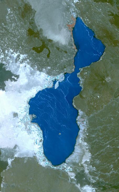
Lake Afrera is a hypersaline lake located in the Danakil Depression in northern Ethiopia. Rock salt has been mined at the lake for centuries. More recently, some companies used to produce salt by pumping brine into artificial ponds for evaporation and subsequent precipitation. Following the 2011 eruption of nearby Nabro volcano, the lake is contaminated with sulfuric acid, making the salt inedible. The single island in the lake, Franchetti Island, is considered the lowest-lying island in the world. The image covers an area of 20 by 33 km, was acquired April 25, 2014, and is located at 13.3 degrees north, 40.9 degrees east.
With its 14 spectral bands from the visible to the thermal infrared wavelength region and its high spatial resolution of 15 to 90 meters (about 50 to 300 feet), ASTER images Earth to map and monitor the changing surface of our planet. ASTER is one of five Earth-observing instruments launched Dec. 18, 1999, on Terra. The instrument was built by Japan's Ministry of Economy, Trade and Industry. A joint U.S./Japan science team is responsible for validation and calibration of the instrument and data products.
The broad spectral coverage and high spectral resolution of ASTER provides scientists in numerous disciplines with critical information for surface mapping and monitoring of dynamic conditions and temporal change. Example applications are: monitoring glacial advances and retreats; monitoring potentially active volcanoes; identifying crop stress; determining cloud morphology and physical properties; wetlands evaluation; thermal pollution monitoring; coral reef degradation; surface temperature mapping of soils and geology; and measuring surface heat balance.
The U.S. science team is located at NASA's Jet Propulsion Laboratory, Pasadena, Calif. The Terra mission is part of NASA's Science Mission Directorate, Washington, D.C.
More information about ASTER is available at http://asterweb.jpl.nasa.gov/.