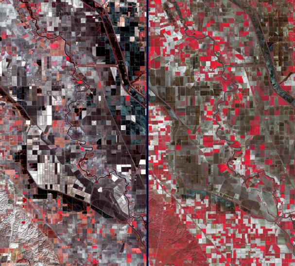
California's severe drought has been particularly devastating to farmers in the Central Valley. Three consecutive years of below-normal rainfall have resulted in the most serious drought emergency in decades. Because California leads the nation in agricultural production and exports, the cost of food, including dairy products and meat, is increasing. Over an area southwest of Sacramento, the effect can be clearly seen in these two February satellite images acquired in 2014 and 2003. Vegetation is depicted in shades of red, while barren fields are dark brown and gray. The left image was acquired on Feb. 11, 2014 by Landsat 8, and the right image was acquired 11 years earlier, on Feb. 8, 2003 by the Advanced Spaceborne Thermal Emission and Reflection Radiometer (ASTER) instrument on NASA's Terra spacecraft. The great increase of barren fields, and the bare hills in the southwest corner, are readily apparent. The images cover an area of 7.4 by 13.5 miles (12 by 21.7 kilometers), and are located at 38.9 degrees north, 121.8 degrees west.
With its 14 spectral bands from the visible to the thermal infrared wavelength region and its high spatial resolution of 15 to 90 meters (about 50 to 300 feet), ASTER images Earth to map and monitor the changing surface of our planet. ASTER is one of five Earth-observing instruments launched Dec. 18, 1999, on Terra. The instrument was built by Japan's Ministry of Economy, Trade and Industry. A joint U.S./Japan science team is responsible for validation and calibration of the instrument and data products.
The broad spectral coverage and high spectral resolution of ASTER provides scientists in numerous disciplines with critical information for surface mapping and monitoring of dynamic conditions and temporal change. Example applications are: monitoring glacial advances and retreats; monitoring potentially active volcanoes; identifying crop stress; determining cloud morphology and physical properties; wetlands evaluation; thermal pollution monitoring; coral reef degradation; surface temperature mapping of soils and geology; and measuring surface heat balance.
The U.S. science team is located at NASA's Jet Propulsion Laboratory, Pasadena, Calif. The Terra mission is part of NASA's Science Mission Directorate, Washington, D.C.
More information about ASTER is available at http://asterweb.jpl.nasa.gov/.