Map Projected Browse Image
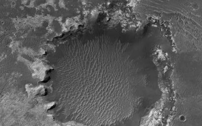
Click on the image for larger versionAn approximately 1-kilometer impact crater located in northern Sinus Meridiani has formed along the boundary of two different terrain units. The western part of the crater has formed along a unit consisting of wind-blown basaltic materials that overlie light-toned units exposed in the crater wall.
To the east is a shallow circular depression several kilometers across that consists of multiple layers of light-toned deposits that have been eroding away. These deposits are dark in THEMIS night-time infrared and bright in day-time infrared images, suggesting that they are relatively fine grained and largely devoid of rocky materials.
Dark, fine-grained basaltic wind-blown material partially mantles these units and forms dunes throughout the region. Along the eastern rim region, the impact crater is eroding back into the terrain, forming scalloped inlets in the crater rim and re-exposing the multiple layers of light-toned deposits. Terracing is common along the eastern slope of the crater.
Turning our attention to the western slope, we see that the rim is eroding back into the terrain more evenly. Although this slope lacks a scalloped appearance, the erosion of the top units appear to be more even and at a faster rate than the underlying light-toned deposits. Dark wind-blown basaltic dunes line the floor of the crater. Some possible explanations for the origin of these light-toned deposits are that they are altered volcanic ash or ancient lake deposits.
HiRISE is one of six instruments on NASA's Mars Reconnaissance Orbiter. The University of Arizona, Tucson, operates the orbiter's HiRISE camera, which was built by Ball Aerospace & Technologies Corp., Boulder, Colo. NASA's Jet Propulsion Laboratory, a division of the California Institute of Technology in Pasadena, manages the Mars Reconnaissance Orbiter Project for the NASA Science Mission Directorate, Washington.

 Planetary Data System


