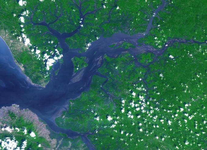
The Sierra Leone estuary became a focal point for trade and interaction between Africans and Europeans because of its exceptional harbor, starting in the mid-15th century. European ships were unable to land along much of the West African coast due to lack of safe anchorage. By contrast, the Sierra Leone estuary offers ideal anchorage for trading ships. Around 1672, the English established and fortified themselves at Bunce Island. By the mid-eighteenth century, Sierra Leone had become a major trading participant with Europe and the Americas. The image was acquired December 28, 2009, covers an area of 32x45 km, and is located at 8.5 degrees north, 13 degrees west.
With its 14 spectral bands from the visible to the thermal infrared wavelength region and its high spatial resolution of 15 to 90 meters (about 50 to 300 feet), ASTER images Earth to map and monitor the changing surface of our planet. ASTER is one of five Earth-observing instruments launched Dec. 18, 1999, on Terra. The instrument was built by Japan's Ministry of Economy, Trade and Industry. A joint U.S./Japan science team is responsible for validation and calibration of the instrument and data products.
The broad spectral coverage and high spectral resolution of ASTER provides scientists in numerous disciplines with critical information for surface mapping and monitoring of dynamic conditions and temporal change. Example applications are: monitoring glacial advances and retreats; monitoring potentially active volcanoes; identifying crop stress; determining cloud morphology and physical properties; wetlands evaluation; thermal pollution monitoring; coral reef degradation; surface temperature mapping of soils and geology; and measuring surface heat balance.
The U.S. science team is located at NASA's Jet Propulsion Laboratory, Pasadena, Calif. The Terra mission is part of NASA's Science Mission Directorate, Washington, D.C.
More information about ASTER is available at http://asterweb.jpl.nasa.gov/.