PIA17924: NASA Radar Maps the Winter Pace of Iceland's Glaciers
 Target Name:  Earth
 Is a satellite of:  Sol (our sun)
 Mission:  UAVSAR
 Product Size:  5184 x 3456 pixels (w x h)
 Produced By:  California Institute of Technology 
 Full-Res TIFF:  PIA17924.tif (53.78 MB)
 Full-Res JPEG:  PIA17924.jpg (1.748 MB)

Click on the image above to download a moderately sized image in JPEG format (possibly reduced in size from original)

Original Caption Released with Image:

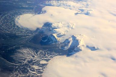
This image shows a small part of the Hofsjökull ice cap in Iceland, which encompasses several glaciers. The fan at upper left is part of a glacier called Mûlajökul.

Click here for Map of Iceland fig1 of PIA17924
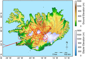
Map of Iceland
The above map shows the flight path (red lines) for a single flight to map flow speeds across two ice caps with the UAVSAR instrument. Each five-hour flight will follow this same complicated path for optimal coverage. The ice caps appear in white in the center of the tangled flight lines; Langjökull is west (left) of Hofsjökull. Keflavik International Airport is on the peninsula in the southwest.

A high-precision radar instrument from NASA's Jet Propulsion Laboratory, Pasadena, Calif., left Southern California for Iceland today to create detailed maps of how glaciers move in the dead of winter. This will help scientists better understand some of the most basic processes involved in melting glaciers, which are major contributors to rising sea levels.

UAVSAR is part of NASA's ongoing effort to apply space-based technologies, ground-based techniques and complex computer models to advance our understanding of Earth deformation processes, such as those caused by earthquakes, volcanoes and landslides. UAVSAR is also serving as a flying test bed to evaluate the tools and technologies for future space-based radars, such as those planned for a NASA Synthetic Aperture Radar (SAR) mission currently in formulation. That mission will study hazards such as earthquakes, volcanoes and landslides, as well as global environmental change.

For more information on UAVSAR, visit http://uavsar.jpl.nasa.gov/.

Image Credit:
Caltech

Image Addition Date:
2014-01-28