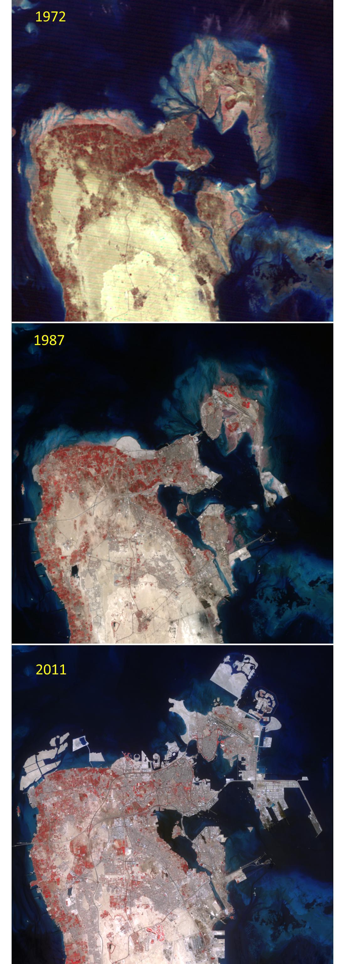
The Kingdom of Bahrain is a small island country near the western shore of the Persian Gulf. In 1971 Bahrain declared independence from its previous status as a United Kingdom protectorate. At that time the population was about 200,000. By 1985, the population had grown to 425,000; and in 2010, the population was over 1,200,000. The rapid development of the country is dramatically seen in the northern half of the country from these three satellite images: acquired in 1972 (Landsat Multispectral Scanner), 1987 (Landsat Thematic Mapper) and 2011 (ASTER). The images cover an area of 30 x 30 km, and are located at 26.2 degrees north, 50.5 degrees east.
With its 14 spectral bands from the visible to the thermal infrared wavelength region and its high spatial resolution of 15 to 90 meters (about 50 to 300 feet), ASTER images Earth to map and monitor the changing surface of our planet. ASTER is one of five Earth-observing instruments launched Dec. 18, 1999, on Terra. The instrument was built by Japan's Ministry of Economy, Trade and Industry. A joint U.S./Japan science team is responsible for validation and calibration of the instrument and data products.
The broad spectral coverage and high spectral resolution of ASTER provides scientists in numerous disciplines with critical information for surface mapping and monitoring of dynamic conditions and temporal change. Example applications are: monitoring glacial advances and retreats; monitoring potentially active volcanoes; identifying crop stress; determining cloud morphology and physical properties; wetlands evaluation; thermal pollution monitoring; coral reef degradation; surface temperature mapping of soils and geology; and measuring surface heat balance.
The U.S. science team is located at NASA's Jet Propulsion Laboratory, Pasadena, Calif. The Terra mission is part of NASA's Science Mission Directorate, Washington, D.C.
More information about ASTER is available at http://asterweb.jpl.nasa.gov/.
 Planetary Data System


