Click on the image for the animation
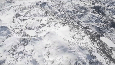
A new NASA airborne mission has created the first maps of the entire snowpack of two major mountain watersheds in California and Colorado, producing the most accurate measurements to date of how much water they hold. The data from NASA's Airborne Snow Observatory mission will be used to estimate how much water will flow out of the basins when the snow melts. The data-gathering technology could improve water management for 1.5 billion people worldwide who rely on snowmelt for their water supply. The mission is a collaboration between NASA's Jet Propulsion Laboratory, Pasadena, Calif., and the California Department of Water Resources in Sacramento.
A Twin Otter aircraft carrying NASA's Airborne Snow Observatory began a three-year demonstration mission in April 2013 that includes weekly flights over the Tuolumne River Basin in California's Sierra Nevada and monthly flights over Colorado's Uncompahgre River Basin. The flights will run through the end of the snowmelt season, which typically occurs in July. The Tuolumne watershed and its Hetch Hetchy Reservoir are the primary water supply for 2.6 million San Francisco Bay Area residents. The Uncompahgre watershed is part of the Upper Colorado River Basin that supplies water to much of the western United States.
For more information about the Airborne Snow Observatory, visit: http://aso.jpl.nasa.gov/. For more on NASA's Airborne Science program, visit: http://airbornescience.nasa.gov.
The California Institute of Technology in Pasadena manages JPL for NASA.