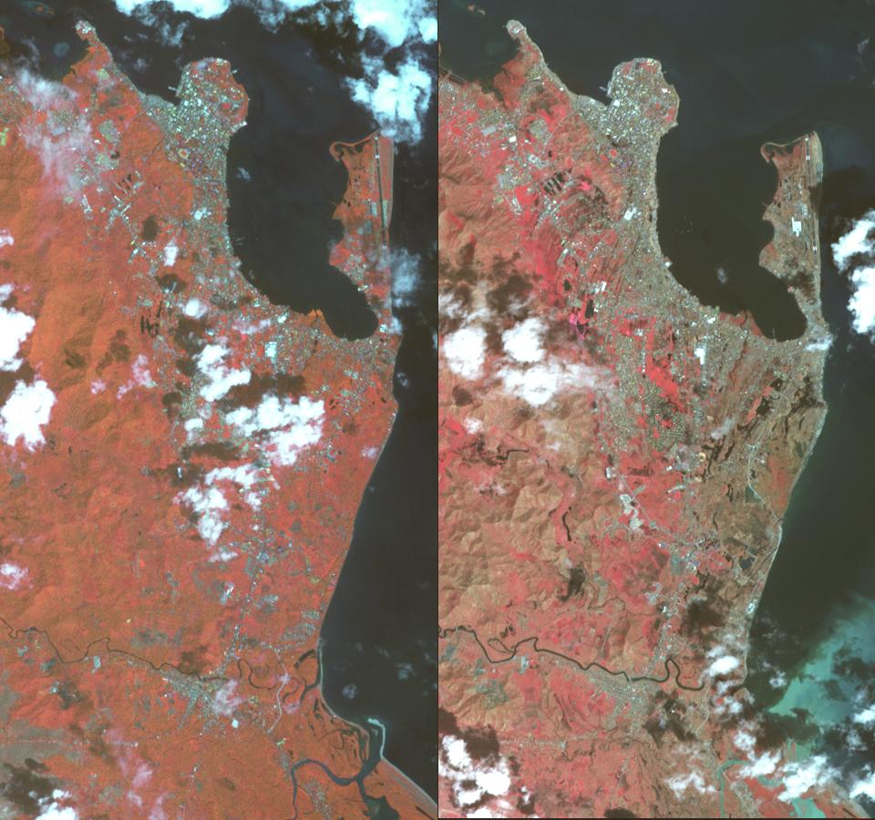
On Nov. 8, 2013, Super Typhoon Haiyan tore across the central Philippines, leaving a trail of destruction in its path. Among the worst-hit areas is eastern Leyte island and the city of Tacloban, where the devastation resembles the aftermath of a tsunami. The Advanced Spaceborne Thermal Emission and Reflection Radiometer (ASTER) instrument on NASA's Terra spacecraft acquired this pair of images on Nov. 14, 2010 (left) and Nov. 15, 2013 (right). Vegetation is depicted in shades of red, bare Earth is brown and urban areas are blue-gray. In the Nov. 15 image, the peninsula of land with the airport is denuded of vegetation, as are the areas southward along the coast and extending inland. Along with removal of vegetation, the hurricane's wind and waves also flattened and uprooted buildings. The images cover an area of 4.3 by 8.4 miles (7.2 by 13.5 kilometers), and are located at 11.1 degrees north latitude, 125 degrees east longitude.
With its 14 spectral bands from the visible to the thermal infrared wavelength region and its high spatial resolution of 15 to 90 meters (about 50 to 300 feet), ASTER images Earth to map and monitor the changing surface of our planet. ASTER is one of five Earth-observing instruments launched Dec. 18, 1999, on Terra. The instrument was built by Japan's Ministry of Economy, Trade and Industry. A joint U.S./Japan science team is responsible for validation and calibration of the instrument and data products.
The broad spectral coverage and high spectral resolution of ASTER provides scientists in numerous disciplines with critical information for surface mapping and monitoring of dynamic conditions and temporal change. Example applications are: monitoring glacial advances and retreats; monitoring potentially active volcanoes; identifying crop stress; determining cloud morphology and physical properties; wetlands evaluation; thermal pollution monitoring; coral reef degradation; surface temperature mapping of soils and geology; and measuring surface heat balance.
The U.S. science team is located at NASA's Jet Propulsion Laboratory, Pasadena, Calif. The Terra mission is part of NASA's Science Mission Directorate, Washington, D.C.
More information about ASTER is available at http://asterweb.jpl.nasa.gov/.
 Planetary Data System


