A large iceberg has finally separated from the calving front of Antarctica's Pine Island Glacier. Scientists first detected a rift in the glacier in October 2011 during flights for NASA's Operation IceBridge. By July 2013, infrared and radar images indicated that the crack had cut completely across the ice shelf to the southwestern edge. Iceberg B-31 is finally moving away from the coast, with open water between the iceberg and the edge of Pine Island Glacier. It is believed the physical separation took place on or about July 10, 2013, however the iceberg persisted in the region, adjacent to the front of the glacier.
The iceberg is estimated to be 21-by-12 miles (35-by-20 kilometers) in size, roughly the size of Singapore.
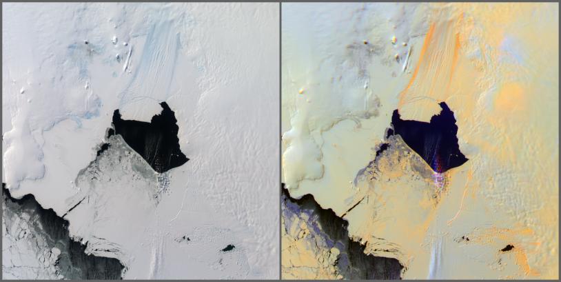
The Multi-angle Imaging SpectroRadiometer (MISR) instrument on NASA's Terra spacecraft passed over the Pine Island Glacier in Antarctica around 15:15 UTC on Oct. 27, 2013, just days before B-31 broke completely free. The left-hand image in this pair shows a true-color view of the glacier from MISR's nadir (0 degree) camera. The image is oriented so that north is to the left and east is toward the top. A large crack is visible in the ice near the center of the image, which is where the iceberg eventually detached. The image on the right is a multi-angle composite made up of red-band images from the 60-degree forward, nadir and 60-degree aftward-looking cameras in the red, green and blue channels, respectively. When visualized in this manner, surfaces that generally scatter light in the backward direction, which tend to be rough surfaces, appear orange, while smooth surfaces, which tend to scatter light in the forward direction, appear blue. A few clouds in the scene, just over the open water below the glacier, appear purple as their location is shifted slightly from one view to the next due to stereo parallax. This parallax is used in MISR processing to retrieve cloud heights over snow and ice. Additionally, a plume of blowing snow can be seen as slightly bluish in the bottom center of the image.
The multi-angle composite shows quite clearly the location of the glacier itself with bright orange bands delineating the extent of the moving ice. The large crack appears in a different color due to the shadowing from the sun, which was shining from the upper left corner of the image. Some snow dunes, or sastrugi, can also be seen in the right center of the image, to the left of the clouds. Again, their orange color is a consequence of the orientation of the sun and the direction of preferential scattering.
The image extends from about 73.57 degrees south to 75.75 degrees south and 97.0 degrees west to 106 degrees west, covering about 224 miles (360 kilometers) in the north-south direction and 140 miles (226 kilometers) in the east-west direction. The images are a portion of the data acquired during Terra orbit 73719 from blocks 151 to 152 within World Reference System-2 path 002.
Iceberg calving events like this one happen about every five to six years at Pine Island Glacier. The last major iceberg broke off there in 2007. This new iceberg is approximately 50 percent larger than previous observed ones. Scientists study this area intensely because it's considered the biggest threat for rapid sea level rise, since the ice sheet is grounded below sea level in West Antarctica.
MISR was built and is managed by NASA's Jet Propulsion Laboratory, Pasadena, Calif., for NASA's Science Mission Directorate, Washington, D.C. The Terra spacecraft is managed by NASA's Goddard Space Flight Center, Greenbelt, Md. The MISR data were obtained from the NASA Langley Research Center Atmospheric Science Data Center, Hampton, Va. JPL is a division of the California Institute of Technology in Pasadena.