PDS logoPlanetary Data System
PDS Information
Find a Node - Use these links to navigate to any of the 8 publicly accessible PDS Nodes.

This bar indicates that you are within the PDS enterprise which includes 6 science discipline nodes and 2 support nodes which are overseen by the Project Management Office at NASA's Goddard Space Flight Center (GSFC). Each node is led by an expert in the subject discipline, supported by an advisory group of other practitioners of that discipline, and subject to selection and approval under a regular NASA Research Announcement.
Click here to return to the Photojournal Home Page Click here to view a list of Photojournal Image Galleries Photojournal_inner_header
Latest Images  |  Spacecraft & Technology  |  Animations  |  Space Images App  |  Feedback  |  Photojournal Search  

PIA17690: Linear Ridges
 Target Name:  Mars
 Is a satellite of:  Sol (our sun)
 Mission:  Mars Reconnaissance Orbiter (MRO)
 Spacecraft:  Mars Reconnaissance Orbiter (MRO)
 Instrument:  HiRISE
 Product Size:  2880 x 1800 pixels (w x h)
 Produced By:  University of Arizona/HiRISE-LPL
 Other  
Information: 
Other products from image ESP_033902_2125
 Full-Res TIFF:  PIA17690.tif (15.56 MB)
 Full-Res JPEG:  PIA17690.jpg (474.1 kB)

Click on the image above to download a moderately sized image in JPEG format (possibly reduced in size from original)

Original Caption Released with Image:

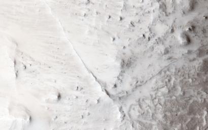
Straight and meandering thin ridges are periodically found on Mars. Such ridges can form in a variety of ways.

Rivers beneath glaciers can deposit rocks and sand leaving a raised ridge, called an esker, when the glacier retreats. Sometimes sandy river beds can become cemented by minerals. Later when the river is gone and the uncemented soils next to the old river bed are eroded more easily, the old river bed itself is left standing.

In this observation, relatively straight and narrow ridges are found crisscrossing the slopes between rocky mesas and adjacent valleys. That these ridges extend along steep slopes is unlike the water-born ridges mentioned above. Additionally, some ridges appear to connect through the mesa and extend also down the opposite slope. These features of the ridges suggest that they cut deep into the interior of the mesas.

A ridge of volcanic rock called a dike occurs when magma is squeezed into a deep fracture in the surrounding rock and upward to (or near) the surface. This magma cools and solidifies into a strong rock that resists erosion better than the fracture rock the magma squeezed into earlier. When erosion of these rocks occurs, the harder volcanic rock is left standing as a ridge and reveals the underground plumbing system of the volcanic vent.

HiRISE is one of six instruments on NASA's Mars Reconnaissance Orbiter. The University of Arizona, Tucson, operates the orbiter's HiRISE camera, which was built by Ball Aerospace & Technologies Corp., Boulder, Colo. NASA's Jet Propulsion Laboratory, a division of the California Institute of Technology in Pasadena, manages the Mars Reconnaissance Orbiter Project for the NASA Science Mission Directorate, Washington.

Image Credit:
NASA/JPL-Caltech/Univ. of Arizona

Image Addition Date:
2013-11-13