PDS logoPlanetary Data System
PDS Information
Find a Node - Use these links to navigate to any of the 8 publicly accessible PDS Nodes.

This bar indicates that you are within the PDS enterprise which includes 6 science discipline nodes and 2 support nodes which are overseen by the Project Management Office at NASA's Goddard Space Flight Center (GSFC). Each node is led by an expert in the subject discipline, supported by an advisory group of other practitioners of that discipline, and subject to selection and approval under a regular NASA Research Announcement.
Click here to return to the Photojournal Home Page Click here to view a list of Photojournal Image Galleries Photojournal_inner_header
Latest Images  |  Spacecraft & Technology  |  Animations  |  Space Images App  |  Feedback  |  Photojournal Search  

PIA17595: View of Yellowknife Bay Formation, with Drilling Sites
 Target Name:  Mars
 Is a satellite of:  Sol (our sun)
 Mission:  Mars Science Laboratory (MSL)
 Spacecraft:  Curiosity
 Instrument:  Mastcam
 Product Size:  9170 x 3590 pixels (w x h)
 Produced By:  Malin Space Science Systems
 Full-Res TIFF:  PIA17595.tif (98.79 MB)
 Full-Res JPEG:  PIA17595.jpg (6.708 MB)

Click on the image above to download a moderately sized image in JPEG format (possibly reduced in size from original)

Original Caption Released with Image:

Click here for larger version of PIA17595
Annotated Version
Click on the image for larger version

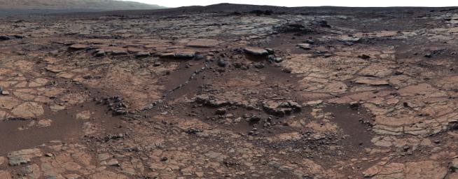
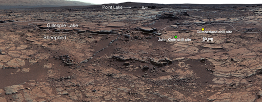
This mosaic of images from Curiosity's Mast Camera (Mastcam) shows geological members of the Yellowknife Bay formation, and the sites where Curiosity drilled into the lowest-lying member, called Sheepbed, at targets "John Klein" and "Cumberland." The scene has the Sheepbed mudstone in the foreground and rises up through Gillespie Lake member to the Point Lake outcrop. These rocks record superimposed ancient lake and stream deposits that offered past environmental conditions favorable for microbial life. Rocks here were exposed about 70 million years ago by removal of overlying layers due to erosion by the wind.

The 50-centimeter scale bars at different locations in the image are about 20 inches long. The lower scale bar is about 26 feet (8 meters) away from where Curiosity was positioned when the view was recorded. The upper scale bar is about 98 feet (30 meters) from the rover's location. The scene is a portion of a 111-image mosaic acquired during the 137th Martian day, or sol, of Curiosity's work on Mars (Dec. 24, 2012). The foothills of Mount Sharp are visible in the distance, upper left, southwest of camera position.

Malin Space Science Systems, San Diego, built and operates Mastcam. NASA's Jet Propulsion Laboratory manages the Mars Science Laboratory mission and the mission's Curiosity rover for NASA's Science Mission Directorate in Washington. The rover was designed, developed and assembled at JPL, a division of the California Institute of Technology in Pasadena.

For more about NASA's Curiosity mission, visit http://www.jpl.nasa.gov/msl, http://www.nasa.gov/mars, and http://marsprogram.jpl.nasa.gov/msl.

Image Credit:
NASA/JPL-Caltech/MSSS

Image Addition Date:
2013-12-09