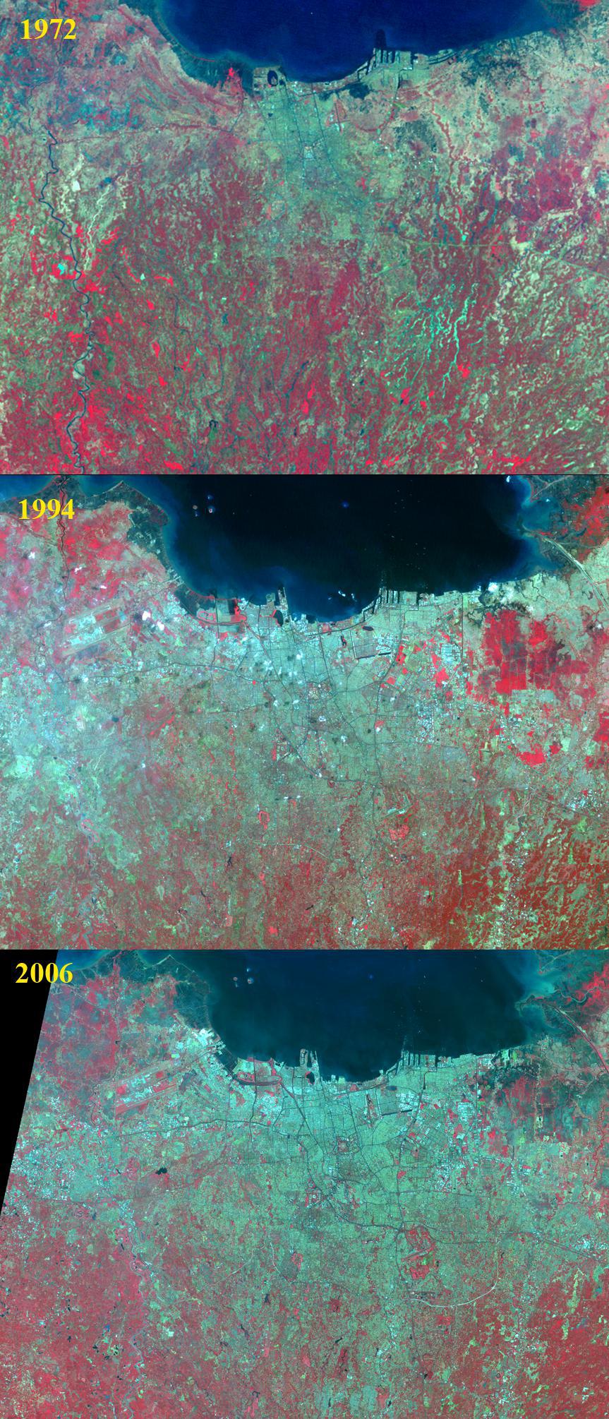
Jakarta is the capital and largest city of Indonesia. The population of the Jakarta conurbation is over 28 million, making it perhaps the largest metropolitan area in the world in terms of inhabitants. Established in the 4th century, it became an important trading port for the Kingdom of Sunda, and was the capital of the Dutch East Indies under the name of Batavia. The rapid growth of the city is illustrated in the three satellite images. In 1972, Landsat MSS captured an image of the city with about 11 million inhabitants. By 1994, the Landsat Thematic Mapper saw a city of 19 million. And in 2006, ASTER imaged a city of 25 million inhabitants. Each image covers an area of 40 by 50 km, and is located at 6.1 degrees south latitude, 106.8 degrees east longitude.
With its 14 spectral bands from the visible to the thermal infrared wavelength region and its high spatial resolution of 15 to 90 meters (about 50 to 300 feet), ASTER images Earth to map and monitor the changing surface of our planet. ASTER is one of five Earth-observing instruments launched Dec. 18, 1999, on Terra. The instrument was built by Japan's Ministry of Economy, Trade and Industry. A joint U.S./Japan science team is responsible for validation and calibration of the instrument and data products.
The broad spectral coverage and high spectral resolution of ASTER provides scientists in numerous disciplines with critical information for surface mapping and monitoring of dynamic conditions and temporal change. Example applications are: monitoring glacial advances and retreats; monitoring potentially active volcanoes; identifying crop stress; determining cloud morphology and physical properties; wetlands evaluation; thermal pollution monitoring; coral reef degradation; surface temperature mapping of soils and geology; and measuring surface heat balance.
The U.S. science team is located at NASA's Jet Propulsion Laboratory, Pasadena, Calif. The Terra mission is part of NASA's Science Mission Directorate, Washington, D.C.
More information about ASTER is available at http://asterweb.jpl.nasa.gov/.
 Planetary Data System


