PDS logoPlanetary Data System
PDS Information
Find a Node - Use these links to navigate to any of the 8 publicly accessible PDS Nodes.

This bar indicates that you are within the PDS enterprise which includes 6 science discipline nodes and 2 support nodes which are overseen by the Project Management Office at NASA's Goddard Space Flight Center (GSFC). Each node is led by an expert in the subject discipline, supported by an advisory group of other practitioners of that discipline, and subject to selection and approval under a regular NASA Research Announcement.
Click here to return to the Photojournal Home Page Click here to view a list of Photojournal Image Galleries Photojournal_inner_header
Latest Images  |  Spacecraft & Technology  |  Animations  |  Space Images App  |  Feedback  |  Photojournal Search  

PIA16635: Different Looks for Titan Lakes
 Target Name:  Titan
 Is a satellite of:  Saturn
 Mission:  Cassini-Huygens
 Spacecraft:  Cassini Orbiter
 Instrument:  Radar Mapper
 Product Size:  1858 x 1354 pixels (w x h)
 Produced By:  JPL
 Full-Res TIFF:  PIA16635.tif (2.519 MB)
 Full-Res JPEG:  PIA16635.jpg (575.6 kB)

Click on the image above to download a moderately sized image in JPEG format (possibly reduced in size from original)

Original Caption Released with Image:

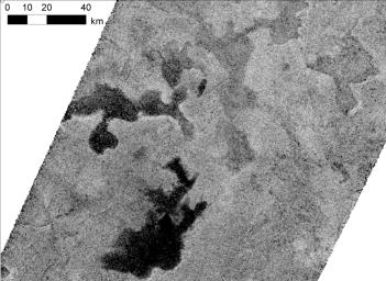
Lakes on Saturn's moon Titan reflect radio waves in varying ways in this image from NASA's Cassini spacecraft. Scientists think the variations in reflectivity, or brightness, have to do with the smoothness or texture of the surface. If a lake is fully liquid, it looks dark, but if it is only partially liquid, it looks brighter.

In this image taken from Titan's high northern latitudes on May 22, 2012, the lakes on the left are full of liquid hydrocarbons and the lakes on the top right are only partially filled, or represent saturated ground (i.e., a mudflat). The lakes in this image are each about 35 to 45 kilometers (22 to 30 miles) across, or about the size of Lake Tahoe on the California-Nevada border. Some of the differences in reflectivity could also be explained by the presence of floating hydrocarbon ice.

This image was obtained by Cassini's radar mapper at a scale of about 350 meters (1,100 feet) per pixel. It is presented in polar stereographic projection with a logarithmic stretch.

For perspective, a wider view of these lakes can be seen in PIA16167.

The Cassini-Huygens mission is a cooperative project of NASA, the European Space Agency and the Italian Space Agency. NASA's Jet Propulsion Laboratory, a division of the California Institute of Technology in Pasadena, manages the mission for NASA's Science Mission Directorate, Washington, DC. The Cassini orbiter was designed, developed and assembled at JPL. The radar instrument was built by JPL and the Italian Space Agency, working with team members from the United States and several European countries.

For more information about the Cassini-Huygens mission, visit http://www.nasa.gov/cassini and http://saturn.jpl.nasa.gov/.

Image Credit:
NASA/JPL-Caltech/ASI/Cornell

Image Addition Date:
2013-01-08