PDS logoPlanetary Data System
PDS Information
Find a Node - Use these links to navigate to any of the 8 publicly accessible PDS Nodes.

This bar indicates that you are within the PDS enterprise which includes 6 science discipline nodes and 2 support nodes which are overseen by the Project Management Office at NASA's Goddard Space Flight Center (GSFC). Each node is led by an expert in the subject discipline, supported by an advisory group of other practitioners of that discipline, and subject to selection and approval under a regular NASA Research Announcement.
Click here to return to the Photojournal Home Page Click here to view a list of Photojournal Image Galleries Photojournal_inner_header
Latest Images  |  Spacecraft & Technology  |  Animations  |  Space Images App  |  Feedback  |  Photojournal Search  

PIA16445: 'Whitewater Lake' Rock Viewed by Opportunity
 Target Name:  Mars
 Is a satellite of:  Sol (our sun)
 Mission:  Mars Exploration Rover (MER)
 Spacecraft:  Opportunity
 Instrument:  Panoramic Camera
 Product Size:  1024 x 1024 pixels (w x h)
 Produced By:  Cornell University 
 Full-Res TIFF:  PIA16445.tif (3.147 MB)
 Full-Res JPEG:  PIA16445.jpg (214.2 kB)

Click on the image above to download a moderately sized image in JPEG format (possibly reduced in size from original)

Original Caption Released with Image:

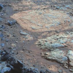
A rind that appears bluish in this false-color view covers portions of the surface of a rock called "Whitewater Lake" in the top half of the view from NASA's Mars Exploration Rover Opportunity. This rind is similar in appearance to weathering rinds previously seen by Opportunity on rocks elsewhere within the Meridiani Planum region where the rover has worked since landing in 2004. Whitewater Lake is in the "Matijevic Hill" portion of the "Cape York" segment of the rim of Endeavour Crater.

The three exposures through different filters that were composited into this image were taken by Opportunity's panoramic camera (Pancam) during the mission's 3,064th Martian day, or sol (Sept. 6, 2012). The view is presented in false color that enhances color differences among various geological materials in the scene.

Whitewater Lake is the large flat rock in the top half of the image. From left to right it is about 30 inches (0.8 meter) across. The dark blue nubby rock to the lower left is "Kirkwood," which bears non-hematite spherules shown in a close-up image at https://photojournal.jpl.nasa.gov/catalog/PIA16139 . The rocks to the lower right look like breccias -- a type of rock containing jumbled fragments cemented together. They resemble other rocks in the area classed as the Shoemaker formation, which is hypothesized to hold deposits of material ejected when an impact excavated Endeavour Crater billions of years ago.

Image Credit:
NASA/JPL-Caltech/USGS/Cornell Univ./Arizona State Univ.

Image Addition Date:
2012-11-12