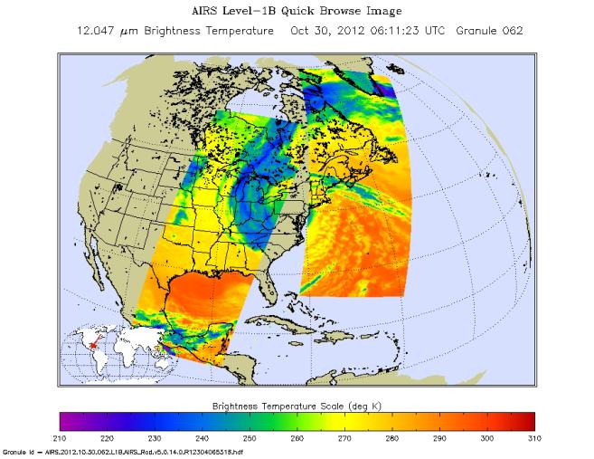
Early Tuesday, Oct. 30, 2012, Hurricane Sandy continued inland, moving to the northwest over Pennsylvania. Swaths of infrared measurements taken over two orbits of NASA's Aqua satellite by the Atmospheric Infrared Sounder are displayed here to show the area of the Northeastern United States and Canada feeling the impact of this large storm at 12:00 a.m. PDT (3:00 a.m. EDT). Each data swath is 1,023 miles across (1,650 kilometers).
The Aqua satellite pursues a sun-synchronous orbit pole-to-pole with a period of 90 minutes while the Earth rotates under the satellite's path. The data swaths do not overlap except near the poles, and so the core of the storm is in the data void between orbits, known as a gore.
About AIRS
The Atmospheric Infrared Sounder, AIRS, in conjunction with the Advanced Microwave Sounding Unit, AMSU, senses emitted infrared and microwave radiation from Earth to provide a three-dimensional look at Earth's weather and climate. Working in tandem, the two instruments make simultaneous observations all the way down to Earth's surface, even in the presence of heavy clouds. With more than 2,000 channels sensing different regions of the atmosphere, the system creates a global, three-dimensional map of atmospheric temperature and humidity, cloud amounts and heights, greenhouse gas concentrations, and many other atmospheric phenomena. Launched into Earth orbit in 2002, the AIRS and AMSU instruments fly onboard NASA's Aqua spacecraft and are managed by NASA's Jet Propulsion Laboratory in Pasadena, Calif., under contract to NASA. JPL is a division of the California Institute of Technology in Pasadena.
More information about AIRS can be found at http://airs.jpl.nasa.gov.
More on NASA's hurricane research and Irene is online at NASA's hurricanes/tropical cyclones website http://www.nasa.gov/mission_pages/hurricanes/main/index.html and the JPL TC-IDEAS hurricane website http://hurricanes.jpl.nasa.gov.