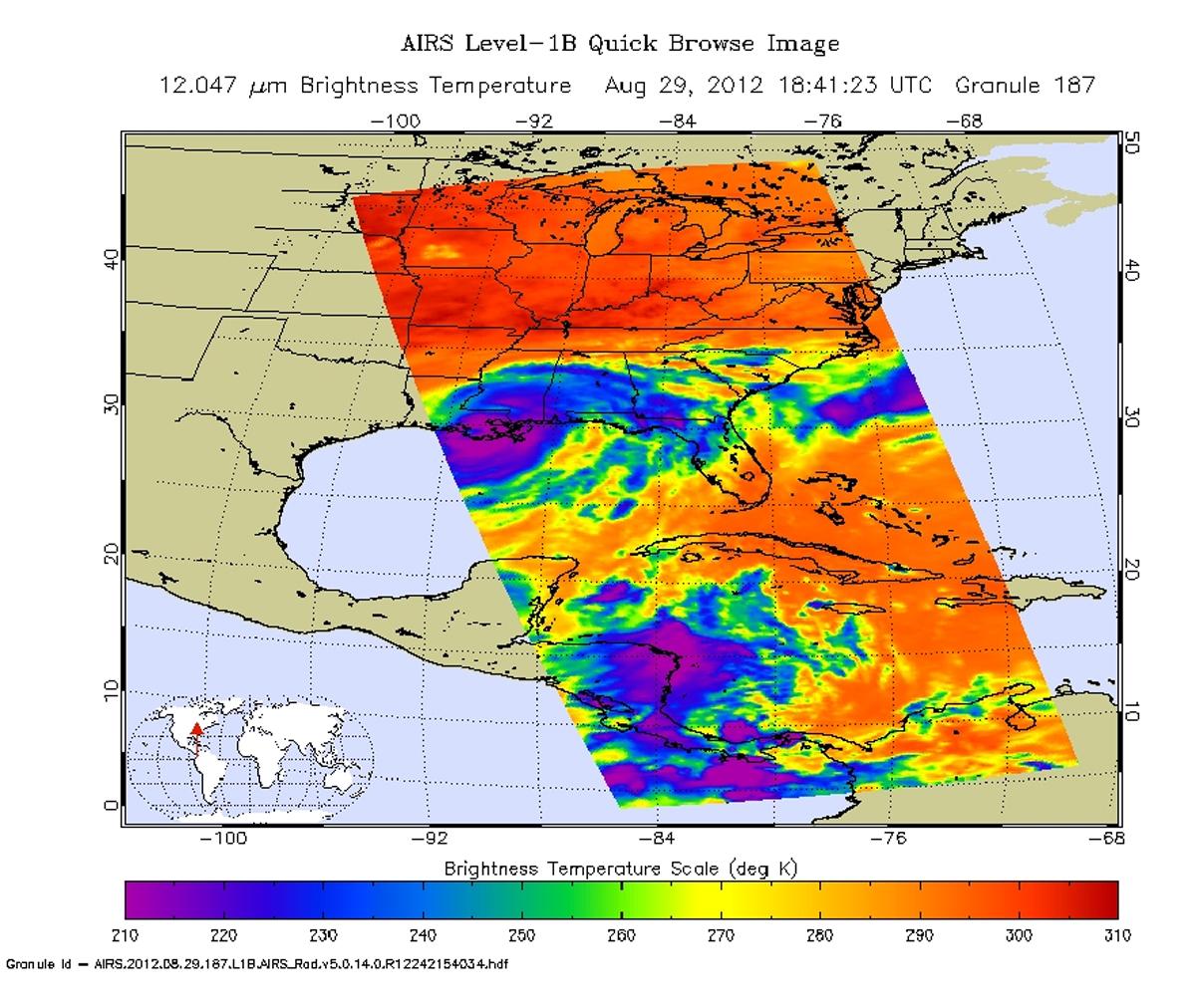
Isaac -- once a Category 1 hurricane and now a strong tropical storm with maximum sustained winds of 70 miles per hour (60 knots) -- continues to create havoc across the Gulf Coast, from eastern Texas to Florida. While "only" reaching Category 1 on the Saffir-Simpson hurricane wind scale upon landfall on Aug. 28, Isaac is a slow mover, crawling along at only about six miles (10 kilometers) per hour. This slow movement is forecast to continue over the next 24 to 36 hours, bringing a prolonged threat of flooding to the northern Gulf Coast and south-central United States.
As seen in this infrared image from the Atmospheric Infrared Sounder (AIRS) instrument on NASA's Aqua spacecraft, acquired at 2:41 p.m. CDT on Aug. 29, 2012, the large storm is still relatively well organized and is producing strong bands of thunderstorms. The broad area of purple in the image represents cloud-top temperatures colder than minus 63 degrees Fahrenheit (minus 52 degrees Celsius) around the center of the storm's circulation. It is here that Isaac's strongest storms and heaviest rainfall are now occurring.
According to the National Oceanic and Atmospheric Administration's National Hurricane Center, strong bands of thunderstorms continue to develop over water in the storm's eastern semicircle and southwest of the center. These strong rain bands are forecast to spread gradually to the west tonight across coastal southeastern Louisiana and southern Mississippi, including the New Orleans metropolitan area. The storm is expected to weaken to a tropical depression by Thursday night and a post-tropical remnant low-pressure system by Friday.
After pounding North Carolina and Virginia on Aug. 27, Hurricane Irene made a second landfall near Little Egg Inlet, N.J., early Sunday morning, Aug. 28, still as a category one hurricane with maximum sustained winds of 75 mph (120 kilometers per hour). It then weakened slightly before making a third landfall over Coney Island, N.Y. as a 65-mph (100-kilometer-per-hour) tropical storm. Irene's heavy rains, winds and storm surge are causing widespread problems throughout the U.S. mid-Atlantic and Northeast.
This infrared image of Irene was taken by the Atmospheric Infrared Sounder (AIRS) instrument on NASA's Aqua spacecraft at 2:47 a.m. EDT on Aug. 27, a few hours before the storm's second landfall in New Jersey.
The AIRS data create an accurate 3-D map of atmospheric temperature, water vapor and clouds, data that are useful to forecasters. The image shows the temperature of Irene's cloud tops or the surface of Earth in cloud-free regions. The coldest cloud-top temperatures appear in purple, indicating towering cold clouds and heavy precipitation. The infrared signal of AIRS does not penetrate through clouds. Where there are no clouds, AIRS reads the infrared signal from the surface of the ocean waters, revealing warmer temperatures in orange and red.<
About AIRS
The Atmospheric Infrared Sounder, AIRS, in conjunction with the Advanced Microwave Sounding Unit, AMSU, senses emitted infrared and microwave radiation from Earth to provide a three-dimensional look at Earth's weather and climate. Working in tandem, the two instruments make simultaneous observations all the way down to Earth's surface, even in the presence of heavy clouds. With more than 2,000 channels sensing different regions of the atmosphere, the system creates a global, three-dimensional map of atmospheric temperature and humidity, cloud amounts and heights, greenhouse gas concentrations, and many other atmospheric phenomena. Launched into Earth orbit in 2002, the AIRS and AMSU instruments fly onboard NASA's Aqua spacecraft and are managed by NASA's Jet Propulsion Laboratory in Pasadena, Calif., under contract to NASA. JPL is a division of the California Institute of Technology in Pasadena.
More information about AIRS can be found at http://airs.jpl.nasa.gov.More on NASA's hurricane research and Irene is online at NASA's hurricanes/tropical cyclones website http://www.nasa.gov/mission_pages/hurricanes/main/index.html and the JPL TC-IDEAS hurricane website http://hurricanes.jpl.nasa.gov.
