PDS logoPlanetary Data System
PDS Information
Find a Node - Use these links to navigate to any of the 8 publicly accessible PDS Nodes.

This bar indicates that you are within the PDS enterprise which includes 6 science discipline nodes and 2 support nodes which are overseen by the Project Management Office at NASA's Goddard Space Flight Center (GSFC). Each node is led by an expert in the subject discipline, supported by an advisory group of other practitioners of that discipline, and subject to selection and approval under a regular NASA Research Announcement.
Click here to return to the Photojournal Home Page Click here to view a list of Photojournal Image Galleries Photojournal_inner_header
Latest Images  |  Spacecraft & Technology  |  Animations  |  Space Images App  |  Feedback  |  Photojournal Search  

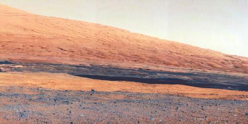
PIA16099: Getting to Know Mount Sharp
 Target Name:  Mars
 Is a satellite of:  Sol (our sun)
 Mission:  Mars Science Laboratory (MSL)
 Spacecraft:  Curiosity
 Instrument:  Mastcam
 Product Size:  3313 x 1660 pixels (w x h)
 Produced By:  Malin Space Science Systems
 Full-Res TIFF:  PIA16099.tif (16.51 MB)
 Full-Res JPEG:  PIA16099.jpg (1.314 MB)

Click on the image above to download a moderately sized image in JPEG format (possibly reduced in size from original)

Original Caption Released with Image:

Click here for larger version of PIA16099
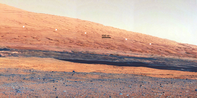
Annotated Version
Click on the image for larger version

This image taken by the Mast Camera (MastCam) on NASA's Curiosity rover highlights the interesting geology of Mount Sharp, a mountain inside Gale Crater, where the rover landed. Prior to the rover's landing on Mars, observations from orbiting satellites indicated that the lower reaches of Mount Sharp, below the line of white dots (Figure 1), are composed of relatively flat-lying strata that bear hydrated minerals. Those orbiter observations did not reveal hydrated minerals in the higher, overlying strata.

The MastCam data now reveal a strong discontinuity in the strata above and below the line of white dots, agreeing with the data from orbit. Strata overlying the line of white dots are highly inclined (dipping from left to right) relative to lower, underlying strata. The inclination of these strata above the line of white dots is not obvious from orbit. This provides independent evidence that the absence of hydrated minerals on the upper reaches of Mount Sharp may coincide with a very different formation environment than lower on the slopes. The train of white dots may represent an "unconformity," or an area where the process of sedimentation stopped.

JPL manages the Mars Science Laboratory/Curiosity for NASA's Science Mission Directorate in Washington. The rover was designed, developed and assembled at JPL, a division of the California Institute of Technology in Pasadena.

For more about NASA's Curiosity mission, visit: http://www.jpl.nasa.gov/msl, http://www.nasa.gov/mars, and http://marsprogram.jpl.nasa.gov/msl.

Image Credit:
NASA/JPL-Caltech/MSSS

Image Addition Date:
2012-08-27