PDS logoPlanetary Data System
PDS Information
Find a Node - Use these links to navigate to any of the 8 publicly accessible PDS Nodes.

This bar indicates that you are within the PDS enterprise which includes 6 science discipline nodes and 2 support nodes which are overseen by the Project Management Office at NASA's Goddard Space Flight Center (GSFC). Each node is led by an expert in the subject discipline, supported by an advisory group of other practitioners of that discipline, and subject to selection and approval under a regular NASA Research Announcement.
Click here to return to the Photojournal Home Page Click here to view a list of Photojournal Image Galleries Photojournal_inner_header
Latest Images  |  Spacecraft & Technology  |  Animations  |  Space Images App  |  Feedback  |  Photojournal Search  

PIA16065: Glenelg Intrigue
 Target Name:  Mars
 Is a satellite of:  Sol (our sun)
 Mission:  Mars Science Laboratory (MSL)
 Spacecraft:  Curiosity
 Instrument:  HiRISE
 Product Size:  3289 x 1958 pixels (w x h)
 Produced By:  University of Arizona/HiRISE-LPL
 Full-Res TIFF:  PIA16065.tif (19.33 MB)
 Full-Res JPEG:  PIA16065.jpg (943.7 kB)

Click on the image above to download a moderately sized image in JPEG format (possibly reduced in size from original)

Original Caption Released with Image:

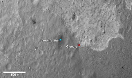
This image shows a closer view of the landing site of NASA's Curiosity rover and a destination nearby known as Glenelg. Curiosity landed inside Gale Crater on Mars on Aug. 5 PDT (Aug. 6 EDT) at the blue dot. It is planning on driving to an area marked with a red dot that is nicknamed Glenelg. That area marks the intersection of three kinds of terrain. Starting clockwise from the top of this image, scientists are interested in this brighter terrain because it may represent a kind of bedrock suitable for eventual drilling by Curiosity. The next terrain shows the marks of many small craters and intrigues scientists because it might represent an older or harder surface. The third, which is the kind of terrain Curiosity landed in, is interesting because scientists can try to determine if the same kind of rock texture at Goulburn, an area where blasts from the descent stage rocket engines scoured away some of the surface, also occurs at Glenelg.

The science team thought the name Glenelg was appropriate because, if Curiosity traveled there, it would visit the area twice -- both coming and going -- and the word Glenelg is a palindrome. After Glenelg, the rover will aim to drive to the base of Mount Sharp.

These annotations have been made on top of an image acquired by the High Resolution Imaging Science Experiment on NASA's Mars Reconnaissance Orbiter.

Image Credit:
NASA/JPL-Caltech/Univ. of Arizona

Image Addition Date:
2012-08-17