PDS logoPlanetary Data System
PDS Information
Find a Node - Use these links to navigate to any of the 8 publicly accessible PDS Nodes.

This bar indicates that you are within the PDS enterprise which includes 6 science discipline nodes and 2 support nodes which are overseen by the Project Management Office at NASA's Goddard Space Flight Center (GSFC). Each node is led by an expert in the subject discipline, supported by an advisory group of other practitioners of that discipline, and subject to selection and approval under a regular NASA Research Announcement.
Click here to return to the Photojournal Home Page Click here to view a list of Photojournal Image Galleries Photojournal_inner_header
Latest Images  |  Spacecraft & Technology  |  Animations  |  Space Images App  |  Feedback  |  Photojournal Search  

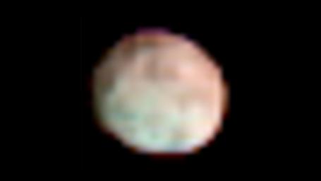
PIA15668: Vesta in the Infrared
 Target Name:  Vesta
 Is a satellite of:  Sol (our sun)
 Mission:  Dawn
 Spacecraft:  Dawn
 Instrument:  VIR
 Product Size:  1280 x 720 pixels (w x h)
 Produced By:  JPL
 Full-Res TIFF:  PIA15668.tif (2.768 MB)
 Full-Res JPEG:  PIA15668.jpg (23.54 kB)

Click on the image above to download a moderately sized image in JPEG format (possibly reduced in size from original)

Original Caption Released with Image:

This global, colorized image of the giant asteroid Vesta from NASA's Dawn mission reveals how the minerals are distributed on the surface. Infrared data from Dawn's visible and infrared mapping spectrometer show Vesta has more large-scale variations in surface material than other asteroids. The northern and equatorial regions, which appear reddish in the spectrometer data, stand in stark contrast to the southern regions, which appear bluish. The composition of the surface in these regions is therefore different. The bluish southern areas represent layers deep below the surface, from the lower crust. Analysis of spectrometer data reveal that the reddish areas are more dominated by rocks that formed volcanically and are richer in iron.

The visible and infrared mapping spectrometer onboard Dawn collects reflected and emitted radiation in a broad range of wavelengths. This colorized image uses three of the instrument's 864 channels.

This image was taken on June 30, 2011, during Dawn's approach to Vesta, from an altitude of about 62,000 miles (99,000 kilometers).

The Dawn mission to Vesta and Ceres is managed by NASA's Jet Propulsion Laboratory, a division of the California Institute of Technology in Pasadena, for NASA's Science Mission Directorate, Washington. UCLA is responsible for overall Dawn mission science. The visible and infrared mapping spectrometer was provided by the Italian Space Agency and is managed by the Italy's National Institute for Astrophysics, Rome, in collaboration with Selex Galileo, where it was built.

More information about Dawn is online at http://www.nasa.gov/dawn and http://dawn.jpl.nasa.gov.

Image Credit:
NASA/JPL-Caltech/UCLA/INAF

Image Addition Date:
2012-05-10