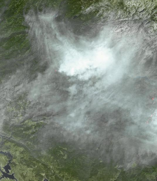
By Sept. 8, 2013 when this image from the Advanced Spaceborne Thermal Emission and Reflection Radiometer (ASTER) instrument on NASA's Terra spacecraft was acquired, the Rim Fire in and around Yosemite National Park in California was 80 percent contained. The wildfire started three weeks ago and has grown to cover more than 250,000 acres, destroying 11 homes and numerous outbuildings. It is now the third largest in California history, and more than 3,100 personnel are still battling the blaze (according to the Los Angeles Times). On the eastern side of the image, actively burning areas are depicted in red as evidenced by the thermal infrared bands. The image covers an area of 37 by 41 miles (60 by 67 kilometers), and is centered near 38 degrees north latitude, 120 degrees west longitude.
With its 14 spectral bands from the visible to the thermal infrared wavelength region and its high spatial resolution of 15 to 90 meters (about 50 to 300 feet), ASTER images Earth to map and monitor the changing surface of our planet. ASTER is one of five Earth-observing instruments launched Dec. 18, 1999, on Terra. The instrument was built by Japan's Ministry of Economy, Trade and Industry. A joint U.S./Japan science team is responsible for validation and calibration of the instrument and data products.
The broad spectral coverage and high spectral resolution of ASTER provides scientists in numerous disciplines with critical information for surface mapping and monitoring of dynamic conditions and temporal change. Example applications are: monitoring glacial advances and retreats; monitoring potentially active volcanoes; identifying crop stress; determining cloud morphology and physical properties; wetlands evaluation; thermal pollution monitoring; coral reef degradation; surface temperature mapping of soils and geology; and measuring surface heat balance.
The U.S. science team is located at NASA's Jet Propulsion Laboratory, Pasadena, Calif. The Terra mission is part of NASA's Science Mission Directorate, Washington, D.C.
More information about ASTER is available at http://asterweb.jpl.nasa.gov/.