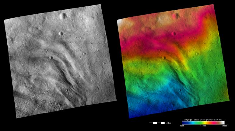
These Dawn FC (framing camera) images show part of the grooved terrain in Vesta's Pinaria quadrangle, which is in the southern hemisphere. Large-scale grooves and depressions can be seen running diagonally across the image. The left image is an albedo image, which is taken directly through the clear filter of the FC. Such an image shows the albedo (eg. brightness/ darkness) of the surface. The right image uses the same albedo image as its base but then a color-coded height representation of the topography is overlain onto it. The topography is calculated from a set of images that were observed from different viewing directions, allowing stereo reconstruction. The various colors correspond to the height of the area. The red area at the top of the image is the highest area and the blue area at the bottom of the image is the lowest area. The topography image does not show major height differences between the grooves and depressions; a higher resolution topography image may be necessary for this. However, the topography image does show that there is a decrease in height from the top to the bottom of the image, which is not clear in the albedo image. Visible in the bottom half of both images are narrow linear scars, which are probably formed by boulders ejected by impacts scouring across Vesta's surface.
These images are centered in Vesta's Pinaria quadrangle and the center latitude and longitude of the image is 49.7°S, 47.3°E. NASA's Dawn spacecraft obtained this image with its framing camera on October 26th 2011. This image was taken through the camera's clear filter. The distance to the surface of Vesta is 700 km and the image has a resolution of about 60 meters per pixel. This image was acquired during the HAMO (High Altitude Mapping Orbit) phase of the mission. The images are lambert-azimuthal map projected.
The Dawn mission to Vesta and Ceres is managed by NASA's Jet Propulsion Laboratory, a division of the California Institute of Technology in Pasadena, for NASA's Science Mission Directorate, Washington D.C. UCLA is responsible for overall Dawn mission science. Dawn's VIR was provided by ASI, the Italian Space Agency and is managed by INAF, Italy's National Institute for Astrophysics, in collaboration with Selex Galileo, where it was built.
More information about Dawn is online at http://www.nasa.gov/dawn and http://dawn.jpl.nasa.gov.