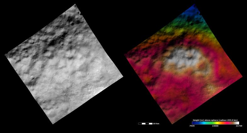
These Dawn FC (framing camera) images show part of the ejecta blanket from Vesta's "Snowman" craters in the northern hemisphere. The ejecta blanket fills the whole image and is identified by its hummocky yet smooth texture. The hummocky texture is due to the undulating hills and depressions across the image. But apart from these hills and depressions the surface is rather smooth. This smoothness is due to the generally small size of particles in ejecta blankets. The left image is an albedo image, which is taken directly through the clear filter of the FC. Such an image shows the albedo (e.g. brightness/darkness) of the surface. The right image uses the same albedo image as its base but then a color-coded height representation of the topography is overlain onto it. The topography is calculated from a set of images that were observed from different viewing directions, allowing stereo reconstruction. The various colors correspond to the height of the area. The white area in the center of the image is the highest area and the blue area in the top of the image is the lowest area. The topography image shows that there are not large height differences between the hills and depressions. But, the topographically high area of ejecta, which is colored white, does become apparent in the topography image.
These images are centered on the border between Vesta's Caparronia and Domitia quadrangles, and also shows part of Marcia quadrangle. The center latitude and longitude of the image is 29.0°N, 179.9°E. NASA's Dawn spacecraft obtained this image with its framing camera on October 26th 2011. This image was taken through the camera's clear filter. The distance to the surface of Vesta is 700 km and the image has a resolution of about 60 meters per pixel. This image was acquired during the HAMO (High Altitude Mapping Orbit) phase of the mission. The images are lambert-azimuthal map projected.
The Dawn mission to Vesta and Ceres is managed by NASA's Jet Propulsion Laboratory, a division of the California Institute of Technology in Pasadena, for NASA's Science Mission Directorate, Washington D.C. UCLA is responsible for overall Dawn mission science. Dawn's VIR was provided by ASI, the Italian Space Agency and is managed by INAF, Italy's National Institute for Astrophysics, in collaboration with Selex Galileo, where it was built.
More information about Dawn is online at http://www.nasa.gov/dawn and http://dawn.jpl.nasa.gov.
 Planetary Data System


