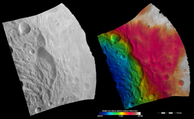
These Dawn FC (framing camera) images show part of the rim of the south polar basin, which is dominated by a large scarp (e.g. cliff) that runs vertically across the center of the images. The piled-up material at the scarp's base is likely due to landsliding. There is also some hummocky (e.g. wavy/undulating) terrain to the left of the scarp. The left image is an albedo image, which is taken directly through the clear filter of the FC. Such an image shows the albedo (e.g. brightness/darkness) of the surface. The right image uses the same albedo image as its base but then a color-coded height representation of the topography is overlain onto it. The topography is calculated from a set of images that were observed from different viewing directions, called stereo images. The various colors correspond to the height of the area that they color. For example, white and red areas on the right are the highest regions and the blue areas on the left are the lowest. The change in color-coded height on the scarp from red to green illustrates its dramatic topographic profile. The blue color-coded hummocky terrain is located on the base of the south polar basin, which is the lowest region in this image.
NASA's Dawn spacecraft obtained the albedo image with its framing camera on August 11th 2011. This image was taken through the camera's clear filter. The distance to the surface of Vesta is 2740 km the image has a resolution of about 250 meters per pixel. The images are projected using a lambert-azimuthal map projection.
The Dawn mission to Vesta and Ceres is managed by NASA's Jet Propulsion Laboratory, a division of the California Institute of Technology in Pasadena, for NASA's Science Mission Directorate, Washington D.C. UCLA is responsible for overall Dawn mission science. Dawn's VIR was provided by ASI, the Italian Space Agency and is managed by INAF, Italy's National Institute for Astrophysics, in collaboration with Selex Galileo, where it was built.
More information about Dawn is online at http://www.nasa.gov/dawn and http://dawn.jpl.nasa.gov.