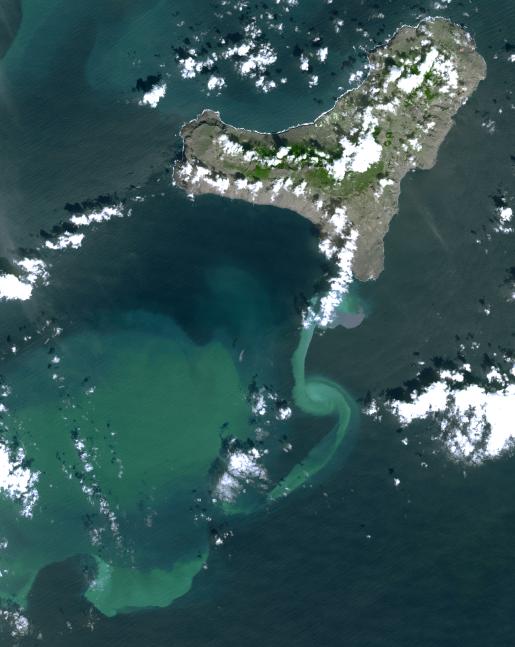
In July 2011, volcanic tremors began on the Island of El Hierro in the Canary Islands; by September, many tourists evacuated the resort island, fearing a volcanic eruption. In early October, an underwater volcanic vent began erupting, sending ash and chemicals into the sea and causing muddy discoloration of the waters south of the island. Reports from a recent underwater survey by a Spanish research vessel revealed the presence of an eruptive vent and crater about 500 feet (150 meters) below the surface, accompanied by submarine "pillow" lavas -- pillow-shaped lavas that form underwater. On November 1, when the Advanced Spaceborne Thermal Emission and Reflection Radiometer (ASTER) instrument on NASA's Terra spacecraft captured this image, the vent location was marked by brownish discoloration off the south tip of the island. Currents diluted and dispersed the volcanic material to the south and west. The image covers an area of 430.1 by 35.3 miles (48.6 by 57 kilometers) and is located near 27.6 degrees north latitude, 18.1 degrees west longitude.
With its 14 spectral bands from the visible to the thermal infrared wavelength region and its high spatial resolution of 15 to 90 meters (about 50 to 300 feet), ASTER images Earth to map and monitor the changing surface of our planet. ASTER is one of five Earth-observing instruments launched Dec. 18, 1999, on Terra. The instrument was built by Japan's Ministry of Economy, Trade and Industry. A joint U.S./Japan science team is responsible for validation and calibration of the instrument and data products.
The broad spectral coverage and high spectral resolution of ASTER provides scientists in numerous disciplines with critical information for surface mapping and monitoring of dynamic conditions and temporal change. Example applications are: monitoring glacial advances and retreats; monitoring potentially active volcanoes; identifying crop stress; determining cloud morphology and physical properties; wetlands evaluation; thermal pollution monitoring; coral reef degradation; surface temperature mapping of soils and geology; and measuring surface heat balance.
The U.S. science team is located at NASA's Jet Propulsion Laboratory, Pasadena, Calif. The Terra mission is part of NASA's Science Mission Directorate, Washington, D.C.
More information about ASTER is available at http://asterweb.jpl.nasa.gov/.