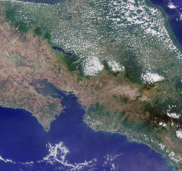
Welcome back to another chance to play geographical detective!
This image was taken by the
Multi-angle Imaging SpectroRadiometer (MISR), and represents an area of about 238 kilometers by 223
kilometers. North is at the top. These questions refer to a country within the image. Please answer the
questions below and tell us where on Earth you think the location is. You may use any reference materials you
like to answer the quiz.
A. From the statements below, please indicate which are TRUE and which are FALSE./
B. What country is shown in this image?
1. The small island off the coastal inlet in the lower left corner of the image is dominated by mangrove swamps,
and considered home to protected sea bird sanctuaries. Parts of the island are off-limits for visitors.
Answer: TRUE
Isla de Chira, or Chira Island, is a Costa Rican Pacific Island located near the upper end of the Gulf of Nicoya,
the largest of several islands in the area. Isla de Chira is surrounded by mangroves, which cover the eastern
end of the island. Popular with pelicans and frigate birds, and uninhabited except for a few fishermen, farmers
and others who eke out a living from salinas (salt pans), these islands are protected seabird sanctuaries and
are off-limits for visitors.
2. Settlers were, perhaps, over-optimistic in their naming policy of this country.
Answer: TRUE
Settlement of Costa Rica began in the 1500s. For nearly three hundred years, Spain administered the region
as part of the Captaincy General of Guatemala under a military governor. The Spanish optimistically called the
country "Rich Coast" ("Costa Rica"). Finding little gold or other valuable minerals in Costa Rica, however, the
Spanish turned to agriculture.
3. The body of water shown on the right side of the image is considered so shallow and is situated on a single
plate, that it is known for its tranquil calm waters and geologic inactivity.
Answer: FALSE
The Caribbean Sea is divided into five basins separated from each other by underwater ridges and mountain
ranges. Despite this, the Caribbean Sea is considered a relatively shallow sea in comparison to other bodies of
water. The Caribbean sea floor is also home to two oceanic trenches: the Hispaniola Trench and Puerto Rico
Trench, which put the area at a higher risk of earthquakes.
4. The streams and rivers of this country used to be home to a sacred reptile, which has since gone extinct.
Answer: FALSE
The "sacred reptile" in question is the Common Basilisk, or Jesus Christ Lizard, found in Central and South
American rainforests. In Costa Rica, it is found mostly on the Pacific side of the country, while the Green lizard
is found on the Atlantic side. It is famous for its ability to walk on water.
5. For centuries, coastal farmers used a powerful fertilizer that covered the rocks on the tip of this peninsula
area during the dry season. Thus giving this area its descriptive name.
Answer: TRUE
The Cabo Blanco Nature Reserve is situated at the extreme southern tip of the Nicoya Peninsula. Since the
times of the Conquistadores, it has been known as the "White Cape" or Cabo Blanco because encrusted
guano covers the rocks in dry season. Guano manure is an effective fertilizer due to its high levels of
phosphorus and nitrogen. It also lacks odor.
6. This animal, which can be found in the National Park located just below the bottom right corner of the image,
comes down from its perch twice a day to feed its young.
Answer: FALSE
The National Park in question is Corcovado National Park, on the south coast of Costa Rica, near to the border
with Panama. Corcovado has been called "the most biologically intense place on Earth" by National
Geographic. It is home to the two-toed sloth, a nocturnal mammal known for its lethargic behavior, which pretty
much spends its life hanging from a tree. The sloth eats, sleeps, mates and gives birth all while hanging
upside down. It descends from the canopy once a week to defecate. Forest guides will tell you that sloths do
not even climb down in the event that their young falls from the tree.
The country shown in this image is Costa Rica.
Quiz Rules
Send us your answers, name (initials are acceptable if you prefer), and your
hometown by the quiz deadline of Wednesday, November 9, 2011, 4 p.m. PST, using the Quiz answer form. Answers will be
published on the MISR website. The names and home towns of respondents who answer all questions
correctly by the deadline will also be published in the order responses were received. The first three people on
this list who are not affiliated with NASA, JPL, or MISR and who have not previously won a prize will be sent a
print of the image. A new "Where on Earth...?" mystery will appear periodically. The image also
appears on the Earth Observatory, http://earthobservatory.nasa.gov/, NASA's Climate Change website, http://climate.nasa.gov/, and on the Atmospheric Sciences
Data Center home pages, http://eosweb.larc.nasa.gov/.Text acknowledgement: Amber Jenkins and Karen
Yuen, JPL.
MISR was built and is managed by NASA's Jet Propulsion Laboratory, Pasadena, Calif., for
NASA's Science Mission Directorate, Washington, D.C. The Terra satellite is managed by NASA's Goddard
Space Flight Center, Greenbelt, Md. The MISR data were obtained from the NASA Langley Research Center
Atmospheric Science Data Center. JPL is a division of the California Institute of Technology.