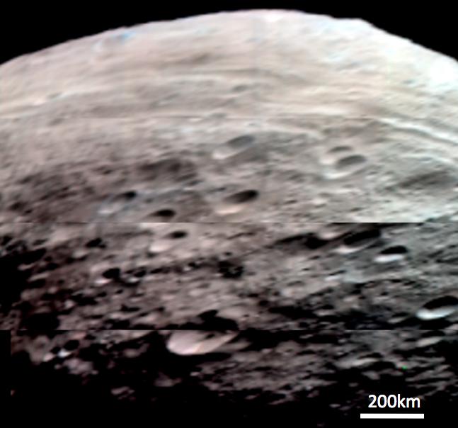
This composite image is a simulated true color image of Vesta's northern and equatorial regions. It was produced by combining images obtained by the Visible and Infrared Imaging Spectrometer (VIR) instrument aboard NASA's Dawn spacecraft. The VIR instrument can image Vesta in many different wavelength regions, called bands, in the near ultraviolet, visible and infrared parts of the electromagnetic spectrum, which corresponds to a wavelength range of 300nm to 5000nm. This is an RGB composite image where red is set as the 700nm band, green is set as the 550nm band and blue is set as the 440nm band. The wavelength of red light is around 700nm, of green light is around 550nm and of blue light is around 440nm, so this image approximates what the human eye would see looking at Vesta. It is an approximation because the human eye can see many more wavelengths than the three used here. This image shows the diverse colors of Vesta's surface: the left and middle parts of the image are dominated by reddish hues and the right part of the image is more blue in color.
NASA's Dawn spacecraft obtained the images used to make this composite image with its Visible and Infrared Imaging Spectrometer on July 23rd 2011. The distance to the surface of Vesta is 5200km and the average image resolution is 1.5 kilometers per pixel.
The Dawn mission to Vesta and Ceres is managed by NASA's Jet Propulsion Laboratory, a division of the California Institute of Technology in Pasadena, for NASA's Science Mission Directorate, Washington. UCLA is responsible for overall Dawn mission science. The visible and infrared mapping spectrometer was provided by the Italian Space Agency and is managed by the Italy's National Institute for Astrophysics, Rome, in collaboration with Selex Galileo, where it was built.
More information about the Dawn mission is online at http://www.nasa.gov/dawn and http://dawn.jpl.nasa.gov.
 Planetary Data System


