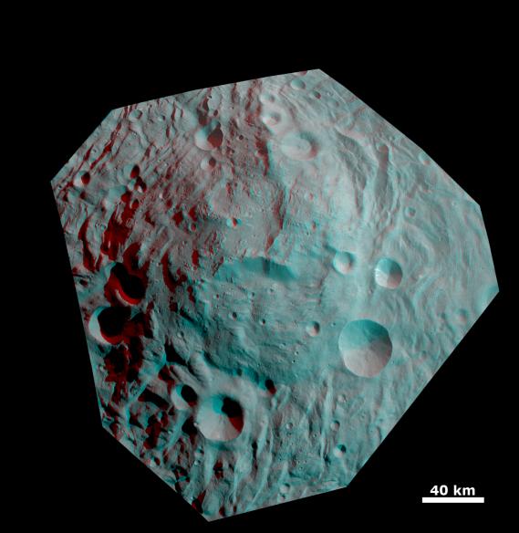
This anaglyph image shows the topography of the mountain/central complex in Vesta's south polar region. When viewed correctly this image shows a 3D view of Vesta's surface. This effect was achieved by superimposing two differently colored images with an offset to create depth. To view this image in 3D use red-green, or red-blue, glasses (left eye: red; right eye: green/blue). The depth effect/topography differences in this image were calculated from the shape model of Vesta. This image is centered on the south polar mountain/central complex, which is a roughly circular topographic mound that is approximately 200km in diameter and has approximately 20km of relief from its base. Surrounding the mountain/central complex is the south polar depression; the relationship between these structures, two of the most prominent Vestan features, is key to understanding the evolution of Vesta as a whole. Also well defined in this image is a large scarp roughly in the center of mountain/central complex.
The framing camera (FC) instrument aboard NASA's Dawn spacecraft obtained the images used to make this anaglyph on 17th and 20th August 2011. The distance from Dawn to the surface of Vesta was 2740km at this time. This image has a resolution of about 260 meters per pixel.
The Dawn mission to Vesta and Ceres is managed by NASA's Jet Propulsion Laboratory, a division of the California Institute of Technology, Pasadena, Calif., for NASA's Science Mission Directorate, Washington. UCLA is responsible for overall Dawn mission science. The Dawn framing cameras were developed and built under the leadership of the Max Planck Institute for Solar System Research, Katlenburg-Lindau, Germany, with significant contributions by DLR German Aerospace Center, Institute of Planetary Research, Berlin, and in coordination with the Institute of Computer and Communication Network Engineering, Braunschweig. The Framing Camera project is funded by the Max Planck Society, DLR, and NASA/JPL.
More information about Dawn is online at http://www.nasa.gov/dawn and http://dawn.jpl.nasa.gov.
 Planetary Data System


