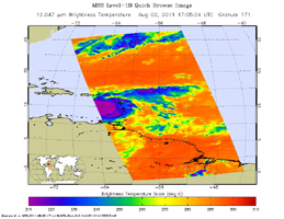
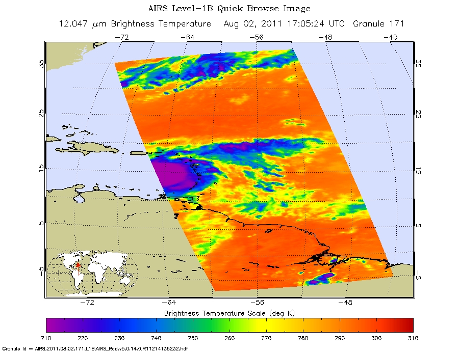
Infrared image
Click on the image for larger viewNASA's Atmospheric Infrared Sounder (AIRS) instrument on the space agency's Aqua spacecraft continues to track the gradual organization of Tropical Storm Emily, as seen in the infrared image (Figure 1) taken Aug. 2, 2011 at 1:05 p.m. EDT. At that time, the storm was located about 270 miles southeast of San Juan, Puerto Rico and nearly stationary in position, with maximum sustained winds of 40 miles per hour (35 knots). As of 5 p.m. EDT, the storm had begun to move slowly westward again and had increased in intensity slightly to about 52 miles per hour (45 knots), with gusts to 63 miles per hour (55 knots). Tropical storm watches are currently in effect for the southeast Bahamas, the Turks and Caicos Islands and the U.S. Virgin Islands. Tropical storm warnings remain in effect for Puerto Rico, Vieques and Culebra, the Dominican Republic and Haiti.
According to the NOAA's National Hurricane Center, the cloud pattern associated with Emily has become slightly better organized, but the storm's circulation is not yet well defined and barometric pressures have not fallen significantly since Aug. 1. Conditions appear favorable for slight strengthening before the storm moves over mountainous Hispaniola on Aug. 3, which may dissipate the storm. Should the storm survive the trip over Hispaniola, upper-level atmospheric winds are forecast to be more conducive for re-intensification once Emily moves over the southeast or central Bahamas. Computer models continue to show a variety of forecasts for the storm, though most of them show Emily moving northward well offshore of the U.S. east coast.
About AIRS
The Atmospheric Infrared Sounder, AIRS, in conjunction with the Advanced Microwave Sounding Unit, AMSU, senses emitted infrared and microwave radiation from Earth to provide a three-dimensional look at Earth's weather and climate. Working in tandem, the two instruments make simultaneous observations all the way down to Earth's surface, even in the presence of heavy clouds. With more than 2,000 channels sensing different regions of the atmosphere, the system creates a global, three-dimensional map of atmospheric temperature and humidity, cloud amounts and heights, greenhouse gas concentrations, and many other atmospheric phenomena. Launched into Earth orbit in 2002, the AIRS and AMSU instruments fly onboard NASA's Aqua spacecraft and are managed by NASA's Jet Propulsion Laboratory in Pasadena, Calif., under contract to NASA. JPL is a division of the California Institute of Technology in Pasadena.
More information about AIRS can be found at http://airs.jpl.nasa.gov.