 |
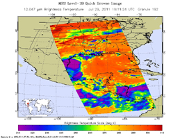
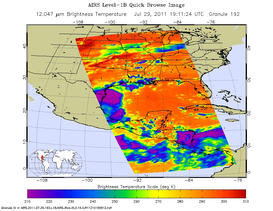
| Figure 1 |
Click on the image for full resolution imageNASA's Aqua spacecraft passed over Tropical Storm Don at 8:17 UTC (1:17 a.m. EDT) on July 29, 2011. Its Atmospheric Infrared Sounder (AIRS) instrument took the temperature of Don's clouds in an infrared image (Figure 1). AIRS data revealed a large area of powerful, high thunderstorms with cold cloud tops surrounding Don's center where cloud temperatures were colder than -63 Fahrenheit (-52 Celsius). The higher the thunderstorm cloud-top, the colder it is, and the more powerful they are.
Don is predicted to make landfall on the southern Texas coast on Friday night, July 29, producing predicted total rainfall accumulations of 2 to 4 inches from south Texas into extreme northeastern Mexico. It remains to be seen whether Don will bring any significant drought relief to Texas, most of which continues to experience exceptional drought conditions, the highest level of drought measured by the U.S. Drought Monitor (see http://droughtmonitor.unl.edu/ ), a synthesis of multiple indices and impacts that represents a consensus of federal and academic scientists. How much drought relief Don provides depends on its intensity, track and forward speed.
About AIRS
The Atmospheric Infrared Sounder, AIRS, in conjunction with the Advanced Microwave Sounding Unit, AMSU, senses emitted infrared and microwave radiation from Earth to provide a three-dimensional look at Earth's weather and climate. Working in tandem, the two instruments make simultaneous observations all the way down to Earth's surface, even in the presence of heavy clouds. With more than 2,000 channels sensing different regions of the atmosphere, the system creates a global, three-dimensional map of atmospheric temperature and humidity, cloud amounts and heights, greenhouse gas concentrations, and many other atmospheric phenomena. Launched into Earth orbit in 2002, the AIRS and AMSU instruments fly onboard NASA's Aqua spacecraft and are managed by NASA's Jet Propulsion Laboratory in Pasadena, Calif., under contract to NASA. JPL is a division of the California Institute of Technology in Pasadena.
More information about AIRS can be found at http://airs.jpl.nasa.gov.
