Welcome back to another chance to play geographical detective!
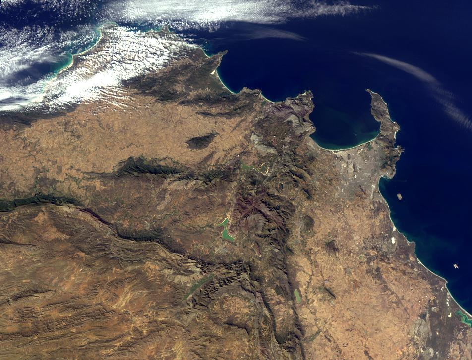
This image was taken by the Multi-angle Imaging SpectroRadiometer (MISR), and represents an area of about 1800 kilometers by 900 kilometers. Please note that due North may not be at the top of the page. These questions refer to a landmark, area or province within the pictured region. Please answer the questions below and tell us where on Earth you think the location is. You may use any reference materials you like to answer the quiz.
From the statements below, please indicate which are TRUE and which are FALSE.
1. Located within the lower third of the image is a dramatic landmark that has lain dormant for thousands of years.
Answer: FALSE
The landmark is within 100 miles of an active volcanic region on Marion Island, one of a group of two islands called the Prince Edward Islands, which are part of South Africa politically. Marion Island forms one of the peaks of a large underwater active volcano that erupted between 1980 and 2004.
2. The southwest part of the region pictured overlooks a capital city.
Answer: TRUE
Table Mountain overlooks Cape Town, the legislative capital of South Africa whose motto is "good hope." Cape Town is also known as Kaapstad (in Afrikaans), iKapa (in Xhosa) and Tavern of the Seas (a nickname). It is South Africa's oldest city and was founded in 1652 when the Dutch East India Company established the first settlement in South Africa there.
3. This area was once rich in biodiversity. However, urbanization over the past several decades has reduced the wealth of flora and fauna in the region by nearly 30 percent.
Answer: FALSE.
The area is home to the "Cape Floral Kingdom," which has a rich diversity of flora and is home to around a fifth of the African continent's plants. It is one of the richest areas for plants in the world.
4. One of the seven natural wonders of the world lies to the northeast of this region, less than a week away by car.
Answer: TRUE
Table Mountain is not far from Victoria Falls, a spectacular waterfall in southern Africa located on the borders of Zambia and Zimbabwe. Also called Mosi-oa-Tunya, or the "smoke that thunders," Victoria Falls is the largest sheet of falling water in the world, based on its width and height. It was named by the Scottish explorer Dr. David Livingstone.
5. The highest point in this region, located near the peninsula shown in the image, was first successfully climbed in the 16th century, according to records.
Answer: TRUE
The highest point in this region is Table Mountain itself (3600 feet or 1100 meters high). The first recorded ascent was in 1503 by Antonia da Saldanha, a Portuguese navigator. da Saldanha, confused by the geography, summited via the front cleft, now known as Plattekip Gorge. For those who want a more relaxing experience, a cable car can take visitors to the top where they will find a restaurant complex.
6. The country in which this region is located is home to one of the world's largest (by volume) rivers.
Answer: FALSE
South Africa, the country in which this image is taken, is actually home to one of the Earth's most ancient scars – the Vredefort Dome. A ring of hills rising from the South Africa plains, Vredefort Dome is the oldest and largest meteorite impact site in the world, created about two billion years ago when a huge asteroid hit the Earth. Geologists estimate that the asteroid was 10 kilometers (over 6 miles) in diameter.
7. On the west coast of the region pictured lies a World Heritage Site surrounded by water.
Answer: TRUE
Robben Island, a Cultural World Heritage UNESCO site, lies off the coast of Cape Town, just a few miles from Table Mountain. It is the site of a notorious prison that housed many political prisoners during the apartheid era, including Nelson Mandela, once the president of South Africa and now Nobel Laureate. Incidentally, the Vredefort Dome (see Question 6) and Cape Floral Protected Areas (see Question 3) are also UNESCO World Heritage sites. South Africa has eight such sites in total.
What location is shown in this image?
Western Cape, South Africa
Quiz Rules Send us your answers, name (initials are acceptable if you prefer), and your hometown by the quiz deadline of Wednesday, August 3, 2011, using the Quiz answer form. Answers will be published on the MISR web site. The names and home towns of respondents who answer all questions correctly by the deadline will also be published in the order responses were received. The first 3 people on this list who are not affiliated with NASA, JPL, or MISR and who have not previously won a prize will be sent a print of the image. A new "Where on Earth...?" mystery will appear periodically. The image also appears on the Earth Observatory, http://earthobservatory.nasa.gov/, and on the Atmospheric Sciences Data Center home pages, http://eosweb.larc.nasa.gov/, though usually with a several-hour delay. Text acknowledgement: Amber Jenkins and Karen Yuen, JPL
