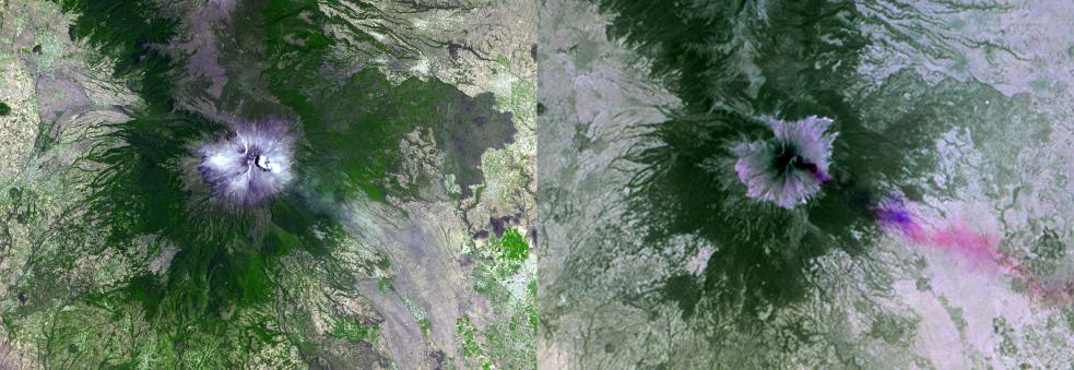
Mexico's active Popocatepetl volcano, located about 40 miles southeast of Mexico City, has been spewing water vapor, gas, ashes and glowing rocks since its most recent eruption period began in April 2012. Civil defense authorities have set up evacuation shelters should they become necessary. In 2000, eruptions of the nearly 18,000-foot-high ( 5,400 meter) volcano led to the evacuation of tens of thousands of residents. More than 30 million people live within sight of the mountain.
The Advanced Spaceborne Thermal Emission and Reflection Radiometer (ASTER) instrument on NASA's Terra spacecraft acquired these two images on April 23, 2012. The left image is in simulated natural color; the right image combines three thermal infrared channels, displaying the eruption plume in purple and pink, blowing toward the northeast. A small hotspot can be seen in the summit crater. The image covers an area of 19.2 by 27.6 miles (30 by 44.5 kilometers) and is located at 19 degrees north latitude, 98.6 degrees west longitude.
With its 14 spectral bands from the visible to the thermal infrared wavelength region and its high spatial resolution of 15 to 90 meters (about 50 to 300 feet), ASTER images Earth to map and monitor the changing surface of our planet. ASTER is one of five Earth-observing instruments launched Dec. 18, 1999, on Terra. The instrument was built by Japan's Ministry of Economy, Trade and Industry. A joint U.S./Japan science team is responsible for validation and calibration of the instrument and data products.
The broad spectral coverage and high spectral resolution of ASTER provides scientists in numerous disciplines with critical information for surface mapping and monitoring of dynamic conditions and temporal change. Example applications are: monitoring glacial advances and retreats; monitoring potentially active volcanoes; identifying crop stress; determining cloud morphology and physical properties; wetlands evaluation; thermal pollution monitoring; coral reef degradation; surface temperature mapping of soils and geology; and measuring surface heat balance.
The U.S. science team is located at NASA's Jet Propulsion Laboratory, Pasadena, Calif. The Terra mission is part of NASA's Science Mission Directorate, Washington, D.C.
More information about ASTER is available at http://asterweb.jpl.nasa.gov/.
 Planetary Data System


