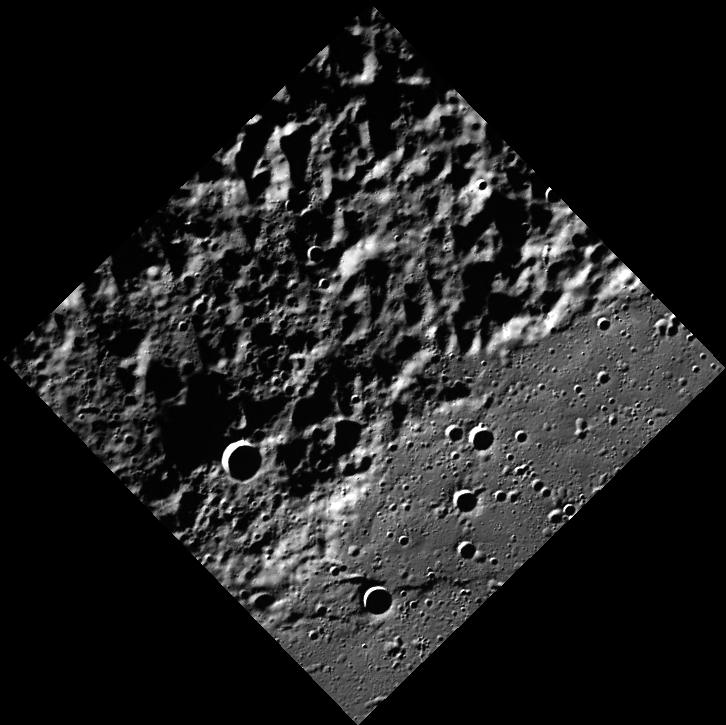
This image reveals previously unseen terrain near Mercury's north pole. There is a sharp boundary between smooth and rough terrain, but without seeing the neighboring areas, the boundary is difficult to interpret. Mosaicking this image with surrounding images will allow MESSENGER scientists to understand the geology of this region.
This image was acquired as part of MDIS's high-resolution surface morphology base map. The surface morphology base map will cover more than 90% of Mercury's surface with an average resolution of 250 meters/pixel (0.16 miles/pixel or 820 feet/pixel). Images acquired for the surface morphology base map typically have off-vertical Sun angles (i.e., high incidence angles) and visible shadows so as to reveal clearly the topographic form of geologic features.
On March 17, 2011 (March 18, 2011, UTC), MESSENGER became the first spacecraft ever to orbit the planet Mercury. The mission is currently in its commissioning phase, during which spacecraft and instrument performance are verified through a series of specially designed checkout activities. In the course of the one-year primary mission, the spacecraft's seven scientific instruments and radio science investigation will unravel the history and evolution of the Solar System's innermost planet. Visit the Why Mercury? section of this website to learn more about the science questions that the MESSENGER mission has set out to answer.
Date acquired: May 22, 2011
Image Mission Elapsed Time (MET): 214546268
Image ID: 284192
Instrument: Wide Angle Camera (WAC) of the Mercury Dual Imaging System (MDIS)
WAC filter: 7 (748 nanometers)
Center Latitude: 82.85°
Center Longitude: 156.3° E
Resolution: 178 meters/pixel
Scale: This image is 128 km (80 mi) from the western corner to the eastern corner.
Incidence Angle: 84.8°
Emission Angle: 0.1°
Phase Angle: 84.7°
These images are from MESSENGER, a NASA Discovery mission to conduct the first orbital study of the innermost planet, Mercury. For information regarding the use of images, see the MESSENGER image use policy.
 Planetary Data System


