PIA14278: NASA's EO-1 Spacecraft Images Chile's Volcanic Eruption
 Target Name:  Earth
 Is a satellite of:  Sol (our sun)
 Mission:  Earth Observing-1 (EO-1)
 Spacecraft:  EO-1
 Instrument:  Advanced Land Imager (ALI)
Hyperion Hyperspectral Imager
 Product Size:  1800 x 1528 pixels (w x h)
 Produced By:  JPL
 Full-Res TIFF:  PIA14278.tif (8.264 MB)
 Full-Res JPEG:  PIA14278.jpg (456 kB)

Click on the image above to download a moderately sized image in JPEG format (possibly reduced in size from original)

Original Caption Released with Image:

Click here for larger version of PIA14278
Hyperion Infrared Image
Click on the image for larger version

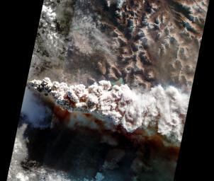
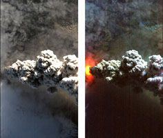
On June 14, 2011, the Hyperion and Advanced Land Imager (ALI) instruments onboard NASA's Earth Observing-1 (EO-1) spacecraft obtained these images of the continuing eruption of Chile's Puyehue-Cordon Caulle volcano. Like the 2010 eruption of Iceland's Eyjafjallajökull volcano, the volcanic ash from the Puyehue eruption is disrupting air travel.

In the main image, created from data at visible wavelengths, the ash-rich volcanic plume billows out of the vent, punching through a low cloud layer. The plume's grey color is a reflection of its ash content. Fine particles of ash are carried high into the atmosphere and get dispersed by the prevailing winds. Ash from the volcano has traveled thousands of kilometers across the Pacific to cause problems for aviation in New Zealand and southeastern Australia.

The smaller image is created from Hyperion visible (left panel) and infrared (right panel) data. In the infrared image, an intense thermal source is revealed at the base of the eruption plume. The thermal emission is at least 1 gigawatt (or 1,000 million watts), nearly 20 times more powerful than the 2010 Eyjafjallajökull eruption and equivalent to the energy consumption of 1 million homes. This is only a fraction of the energy being released during the volcanic eruption.

The main scene depicted here is about 19 miles (30 kilometers) wide, and has a resolution of 98 feet (30 meters) per pixel. The vertical direction is north. The small Hyperion images are each 4.8 miles (7.7 kilometers) across.

The EO-1 spacecraft is managed by NASA's Goddard Space Flight Center, Greenbelt, Md. EO-1 is the satellite remote-sensing asset used by the Volcano Sensor Web developed by NASA's Jet Propulsion Laboratory, Pasadena, Calif., which is being used to monitor this, and other, volcanic eruptions around the world.

Image Credit:
NASA/JPL/EO-1 Mission/GSFC/Ashley Davies

Image Addition Date:
2011-06-17